IMAGES TAKEN NEAR TO
Horseshoe Crescent, SOUTHEND-ON-SEA, SS3 9WL
Introduction
This page details the photographs taken nearby to Horseshoe Crescent, SS3 9WL by members of the Geograph project.
The Geograph project started in 2005 with the aim of publishing, organising and preserving representative images for every square kilometre of Great Britain, Ireland and the Isle of Man.

There are currently over 7.5m images from over14,400 individuals and you can help contribute to the project by visiting https://www.geograph.org.uk
Image Map
Images are licensed for reuse under creativecommons.org/licenses/by-sa/2.0
Notes
- Clicking on the map will re-center to the selected point.
- The higher the marker number, the further away the image location is from the centre of the postcode.
Image Listing (170 Images Found)
Images are licensed for reuse under creativecommons.org/licenses/by-sa/2.0
Image
Details
Distance
1
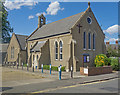
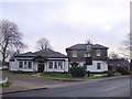
Shoeburyness : St Peter's Church, South Shoebury
A converted Victorian school.
Image: © Jim Osley
Taken: 28 Jul 2018
0.02 miles
2
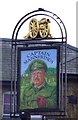
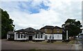
Captain Mannering
This pub used to be the HQ of Shoebury Garrison, but was originally built as a memorial hospital for soldiers and their families. The building was funded by public donations. It was built in 1898 but was converted into Captain Mannering's pub and restaurant in 1984 after the hospital closed after WW2.
Image
Image: © Julieanne Savage
Taken: 4 Feb 2007
0.02 miles
3
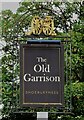
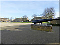
Sign for the Old Garrison, Shoeburyness
See Image] for context.
Image: © JThomas
Taken: 23 Aug 2022
0.03 miles
4
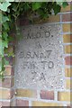
Old Boundary Marker by Campfield Road, Southend on Sea
Estate Boundary Marker - MOD by the UC road, in parish of Southend on Sea (Southend on Sea District), Campfield Road, in barracks wall opposite Hinguar Street.
Inscription reads:-
M.O.D.
^
B.S.NO.7
F.W. TO
7 A
Surveyed
Milestone Society National ID: EX_MODSHO07em
Image: © Milestone Society
Taken: Unknown
0.03 miles
5
Captain Mannerings Pub
This pub used to be the HQ of Shoebury Garrison, but was originally built as a memorial hospital for soldiers and their families. The building was funded by public donations. It was built in 1898 but was converted into Captain Mannering's pub and restaurant in 1984 after the hospital closed after WW2.
Image
Image: © Julieanne Savage
Taken: 4 Feb 2007
0.04 miles
6
The Old Garrison, Shoeburyness
On Campfield Road.
See Image] for sign.
Image: © JThomas
Taken: 23 Aug 2022
0.04 miles
7
Former Horseshoe Barracks, Shoebury Garrison
Barrack blocks, eight in all, arranged in a horseshoe around a parade ground. Grade II listed, 1859.
Image: © Robin Webster
Taken: 5 Feb 2023
0.05 miles
8
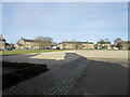
Former Horseshoe Barracks, Shoebury Garrison
Barrack blocks, eight in all, arranged in a horseshoe around a parade ground. Grade II listed, 1859.
Image: © Robin Webster
Taken: 5 Feb 2023
0.05 miles
9
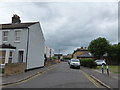
Looking south-southwest along Hinguar Street
Image: © Basher Eyre
Taken: 19 Jul 2020
0.05 miles
10
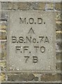
Old Boundary Marker by Campfield Road, Southend on Sea
Estate Boundary Marker - MOD by the UC road, in parish of Southend on Sea (Southend on Sea District), Campfield Road, on angle of barracks wall opposite Rosewood Lane.
Inscription reads:-
M.O.D.
^
B.S.No.7A
F.F. TO
7B
Surveyed
Milestone Society National ID: EX_MODSHO07Aem
Image: © Milestone Society
Taken: Unknown
0.06 miles