IMAGES TAKEN NEAR TO
Hale Way, SOUTHEND-ON-SEA, SS3 9GB
Introduction
This page details the photographs taken nearby to Hale Way, SS3 9GB by members of the Geograph project.
The Geograph project started in 2005 with the aim of publishing, organising and preserving representative images for every square kilometre of Great Britain, Ireland and the Isle of Man.

There are currently over 7.5m images from over14,400 individuals and you can help contribute to the project by visiting https://www.geograph.org.uk
Image Map (Loading...)


Getting Data...Please wait
Leaflet Map data © OpenStreetMap
Images are licensed for reuse under creativecommons.org/licenses/by-sa/2.0
Notes
- Clicking on the map will re-center to the selected point.
- The higher the marker number, the further away the image location is from the centre of the postcode.
Image Listing (177 Images Found)
Images are licensed for reuse under creativecommons.org/licenses/by-sa/2.0
Image
Details
Distance
1

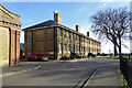
Rear of Long Course Officers' Quarters, Shoeburyness
Now converted for residential use.
Image: © David Kemp
Taken: 25 Dec 2011
0.03 miles
2
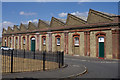
Shoebury Garrison : Gunnery Drill Shed
Built in 1859. Grade II listed - description at this https://historicengland.org.uk/listing/the-list/list-entry/1322358.
Image: © Jim Osley
Taken: 28 Jul 2018
0.03 miles
3
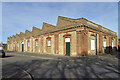
The Gunnery Drill Shed, former Shoebury Garrison
A grade II listed building, 1859, when the first British School of Gunnery was set up at Shoebury.
Image: © Robin Webster
Taken: 5 Feb 2023
0.03 miles
4
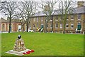
Gunners House & Memorial
Gunners House has been converted into flats, the memorial was erected to mark the centenary of a tragic accidental detonation of a shell. See Image for an explanation
and Image to take a closer look at the shell.
Image: © Glyn Baker
Taken: 22 Jan 2011
0.03 miles
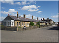
5
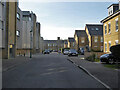
Parade Walk, Shoeburyness
In the redeveloped Shoebury Garrison site, modern flats on the left, on the right modern housing matching, more or less, the style and colour of the original buildings. One of the original buildings is glimpsed at the far end, single officers' quarters.
Image: © Robin Webster
Taken: 5 Feb 2023
0.04 miles
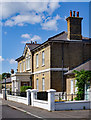
6
Long course single officers' quarters, former Shoebury Garrison
A grade II listed building, 1871. The 'long course' refers to the School of Gunnery here.
Image: © Robin Webster
Taken: 5 Feb 2023
0.04 miles
7
Shoeburyness : Hospital Road
Featured in this view are Blocks K-M - https://historicengland.org.uk/listing/the-list/list-entry/1112690 - and the former hospital building, dated 1856 - https://historicengland.org.uk/listing/the-list/list-entry/1236472 - of the Shoebury Garrison - both are Grade II listed.
Image: © Jim Osley
Taken: 28 Jul 2018
0.04 miles
8
Shoebury Garrison : Hospital
The hospital for Shoebury Garrison was built in 1856, and is Grade II listed - https://historicengland.org.uk/listing/the-list/list-entry/1236472. Like most of the buildings of the former garrison, it has been converted to residential use.
Image: © Jim Osley
Taken: 28 Jul 2018
0.04 miles
9
Shoebury Garrison : Hospital
Attached Block I to Hospital - Grade II listed - https://historicengland.org.uk/listing/the-list/list-entry/1236472.
Image: © Jim Osley
Taken: 28 Jul 2018
0.04 miles
10

Gunnery Drill Shed, Shoeburyness
This building stands on Chapel Road and dates from 1859. Semi-derelict until quite recently, it has now been converted for residential use.
Image: © David Kemp
Taken: 25 Dec 2011
0.05 miles