
IMAGES TAKEN NEAR TO
Rosewood Lane, SOUTHEND-ON-SEA, SS3 9EL
Introduction
This page details the photographs taken nearby to Rosewood Lane, SS3 9EL by members of the Geograph project.
The Geograph project started in 2005 with the aim of publishing, organising and preserving representative images for every square kilometre of Great Britain, Ireland and the Isle of Man.

There are currently over 7.5m images from over14,400 individuals and you can help contribute to the project by visiting https://www.geograph.org.uk
Image Map
Images are licensed for reuse under creativecommons.org/licenses/by-sa/2.0
Notes
- Clicking on the map will re-center to the selected point.
- The higher the marker number, the further away the image location is from the centre of the postcode.
Image Listing (104 Images Found)
Images are licensed for reuse under creativecommons.org/licenses/by-sa/2.0
Image
Details
Distance
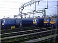
2
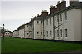
Rear of former Sergeants' Married Quarters, Thorpe Green, Shoeburyness
Once known as 'The Birdcage', these buildings were constructed just after nearby Campfield Road was laid down in 1886. They have now been converted for residential use.
Image: © David Kemp
Taken: 28 Dec 2011
0.05 miles
3
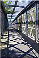
Footbridge over the railway at Shoeburyness
Well boxed in for safety reasons, the footbridge ends up feeling like a cage.
Image: © Stephen McKay
Taken: 11 Aug 2022
0.05 miles
4
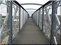
Shoeburyness railway footbridge
The footbridge, which is amazingly free of graffiti, spans the railway sidings at Shoeburyness Depot, and joins Shoebury Avenue and Ness Road.
Image: © Nigel Cox
Taken: 3 Aug 2008
0.05 miles
5
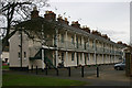
Front of former Sergeants' Married Quarters, Thorpe Green, Shoeburyness
Once known as 'The Birdcage', these buildings were constructed just after nearby Campfield Road was laid down in 1886. They have now been converted for residential use.
Image: © David Kemp
Taken: 28 Dec 2011
0.06 miles
6
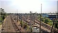
Under the lines at the end of the line
Stock holding sidings at end of old London, Tilbury and Southend line from Fenchurch Street
Image: © Chris Morgan
Taken: 12 Jun 2015
0.07 miles
7
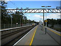
Shoeburyness railway station
Looking towards the buffer stops from the end of platform 2. From this angle, the platforms look absurdly long, appearing to dwarf the eight coach train standing at platform 1 (two of c2c's class 357 electric units, forming the 1609 departure to London Liverpool Street via Basildon).
Image: © Richard Vince
Taken: 14 Aug 2021
0.07 miles
8
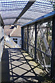
Footbridge over the railway at Shoeburyness
The footbridge is well boxed in; it leads down steps here to Wallace Street.
Image: © Stephen McKay
Taken: 11 Aug 2022
0.08 miles
9
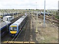
Shoeburyness railway depot
It being a Sunday morning massed ranks of c2c trains are parked up on the extensive sidings of Shoeburyness Depot. The train in the foreground is however on the move with unit number 357046 trailing. The main line to London is beyond the trains on the right.
Image: © Nigel Cox
Taken: 3 Aug 2008
0.08 miles
10
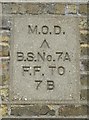
Old Boundary Marker by Campfield Road, Southend on Sea
Estate Boundary Marker - MOD by the UC road, in parish of Southend on Sea (Southend on Sea District), Campfield Road, on angle of barracks wall opposite Rosewood Lane.
Inscription reads:-
M.O.D.
^
B.S.No.7A
F.F. TO
7B
Surveyed
Milestone Society National ID: EX_MODSHO07Aem
Image: © Milestone Society
Taken: Unknown
0.09 miles