IMAGES TAKEN NEAR TO
High Street, SOUTHEND-ON-SEA, SS3 9AS
Introduction
This page details the photographs taken nearby to High Street, SS3 9AS by members of the Geograph project.
The Geograph project started in 2005 with the aim of publishing, organising and preserving representative images for every square kilometre of Great Britain, Ireland and the Isle of Man.

There are currently over 7.5m images from over14,400 individuals and you can help contribute to the project by visiting https://www.geograph.org.uk
Image Map
Images are licensed for reuse under creativecommons.org/licenses/by-sa/2.0
Notes
- Clicking on the map will re-center to the selected point.
- The higher the marker number, the further away the image location is from the centre of the postcode.
Image Listing (120 Images Found)
Images are licensed for reuse under creativecommons.org/licenses/by-sa/2.0
Image
Details
Distance
1
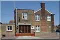
Shoeburyness fire station
Shoeburyness fire station, Shoebury Avenue, Shoeburyness, Southend-on-Sea, Essex
Image: © Kevin Hale
Taken: 4 Jun 2010
0.04 miles
2
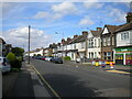
High Street, Shoeburyness
North of the railway station.
Image: © Richard Vince
Taken: 14 Aug 2021
0.07 miles
3
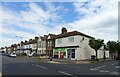
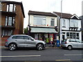
Shop and houses on High Street, Shoeburyness
Image: © JThomas
Taken: 23 Aug 2022
0.07 miles
4
South end of Gunners Road, Shoeburyness
Off High Street.
Image: © Richard Vince
Taken: 14 Aug 2021
0.07 miles
5
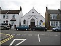
Shoebury Hall
Shoebury Hall is on the east side of Wakering Avenue at its junction with Friars Street in which the photographer was standing when this image was taken. According to the notice board outside it is now Shoebury Gospel Hall.
Image: © Nigel Cox
Taken: 3 Aug 2008
0.09 miles
6
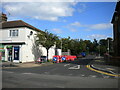
Post Office and shop on High Street, Shoeburyness
Image: © JThomas
Taken: 23 Aug 2022
0.09 miles
7
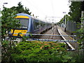
Shoeburyness railway station
The London Tilbury and Southend Railway reached Southend in 1856 but the extension to Shoeburyness was not completed until 1884. This is the very end of the line with a c2c service headed by unit number 357008 just having arrived from London Fenchurch Street.
From a Geograph aspect there are several other images taken from this viewpoint but all placed, wrongly in my opinion, in Image The Ordnance Survey 1:10,000 scale map clearly shows that the first forty metres or so of trackwork are clearly in this square.
Image: © Nigel Cox
Taken: 3 Aug 2008
0.10 miles
8
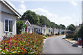
Shoeburyness : Residential park
Large development of factory built chalet-type bungalows.
Image: © Jim Osley
Taken: 28 Jul 2018
0.10 miles
9
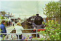
76079 at Shoeburyness, 2001
On one of the 'Cockney Coaster' steam specials from Fenchurch Street to Shoeburyness and back by various routes.
Image: © Robin Webster
Taken: 6 May 2001
0.11 miles
10
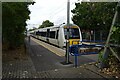
Shoeburyness Railway Station
C2C Class 357, No. 357035.
Image: © JThomas
Taken: 23 Aug 2022
0.11 miles