IMAGES TAKEN NEAR TO
Smith Street, SOUTHEND-ON-SEA, SS3 9AL
Introduction
This page details the photographs taken nearby to Smith Street, SS3 9AL by members of the Geograph project.
The Geograph project started in 2005 with the aim of publishing, organising and preserving representative images for every square kilometre of Great Britain, Ireland and the Isle of Man.

There are currently over 7.5m images from over14,400 individuals and you can help contribute to the project by visiting https://www.geograph.org.uk
Image Map
Images are licensed for reuse under creativecommons.org/licenses/by-sa/2.0
Notes
- Clicking on the map will re-center to the selected point.
- The higher the marker number, the further away the image location is from the centre of the postcode.
Image Listing (184 Images Found)
Images are licensed for reuse under creativecommons.org/licenses/by-sa/2.0
Image
Details
Distance
3
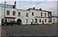
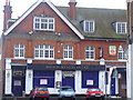
Premises on High Street, Shoeburyness
Believed to be built about 1870.
Image: © Robin Webster
Taken: 5 Feb 2023
0.03 miles
4
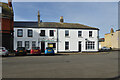
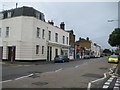
Shoeburyness Hotel, High Street, Shoeburyness.
Now a redundant old relic, this pub pulled its last pint in 2004 before the owners disappeared. Since then there have been many plans to 'develop' the building, but none coming to fruition. The Shoe still stands right at the end of the high street in front of Rampart Street and the entrance to the Garrison.
I was told by a nearby shop-keeper that the last owners gutted the place when they left. It has remained empty ever since which seems a shame as some good times were had in here.
Image: © Julieanne Savage
Taken: 9 Dec 2006
0.04 miles
5
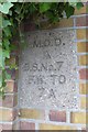
Old Boundary Marker by Campfield Road, Southend on Sea
Estate Boundary Marker - MOD by the UC road, in parish of Southend on Sea (Southend on Sea District), Campfield Road, in barracks wall opposite Hinguar Street.
Inscription reads:-
M.O.D.
^
B.S.NO.7
F.W. TO
7 A
Surveyed
Milestone Society National ID: EX_MODSHO07em
Image: © Milestone Society
Taken: Unknown
0.04 miles
6
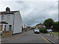
Looking south-southwest along Hinguar Street
Image: © Basher Eyre
Taken: 19 Jul 2020
0.04 miles
7
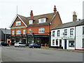
The Shoeburyness Hotel
Strategically situated just outside the East Gate of the former garrison here.
Image: © Robin Webster
Taken: 11 Aug 2015
0.04 miles
9
Shoebury: High Street
The villages of South and North Shoebury were once known as Shoebury Magna and Shoebury Parva and then as Great and Little Shoebury respectively. Shoeburyness is the administrative district that now covers them both. This is the High Street.
Image: © Nigel Cox
Taken: 3 Aug 2008
0.05 miles