IMAGES TAKEN NEAR TO
Chedington, SOUTHEND-ON-SEA, SS3 8UR
Introduction
This page details the photographs taken nearby to Chedington, SS3 8UR by members of the Geograph project.
The Geograph project started in 2005 with the aim of publishing, organising and preserving representative images for every square kilometre of Great Britain, Ireland and the Isle of Man.

There are currently over 7.5m images from over14,400 individuals and you can help contribute to the project by visiting https://www.geograph.org.uk
Image Map (Loading...)


Getting Data...Please wait
Leaflet Map data © OpenStreetMap
Images are licensed for reuse under creativecommons.org/licenses/by-sa/2.0
Notes
- Clicking on the map will re-center to the selected point.
- The higher the marker number, the further away the image location is from the centre of the postcode.
Image Listing (23 Images Found)
Images are licensed for reuse under creativecommons.org/licenses/by-sa/2.0
Image
Details
Distance
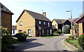
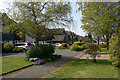
2
Buckland, Thorpe Bay
This is the western branch of the cul-de-sac.
Image: © David Kemp
Taken: 18 Apr 2014
0.06 miles
4
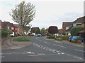
Bishopsteignton, Shoeburyness
Taken from the junction with Kingsteignton looking north.
Image: © David Kemp
Taken: 18 Apr 2014
0.10 miles
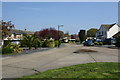
5
Hayes Barton, Shoeburyness
Taken from The Campions.
Image: © David Kemp
Taken: 15 Apr 2019
0.11 miles
6
Kingsteignton, Shoeburyness
Taken at the junction with Bishopsteignton.
Image: © David Kemp
Taken: 18 Apr 2014
0.11 miles
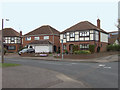
7
Junction of Maplin Way North (left) & Burlescoombe Road (right), Thorpe Bay
Traditional Southend street signs such as this have been slowly diminishing in number over the last couple of decades.
Image: © David Kemp
Taken: 18 Apr 2014
0.13 miles
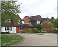
8
North-east end of Plymtree, Thorpe Bay
This is where Plymtree once more becomes a single carriageway.
Image: © David Kemp
Taken: 15 Apr 2019
0.14 miles
9
Plymtree, Thorpe Bay
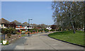
This shows the part of Plymtree where it forms a dual carriageway divided by an expanse of grass and trees.
Image: © David Kemp
Taken: 15 Apr 2019
0.14 miles
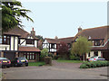
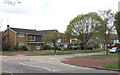
10
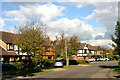
Large family homes, Shoeburyness
Properties such as these are typical of much of this square. The area was open farmland within living memory. Taken in Bishopsteignton looking north-east towards Withypool (whose street sign can be seen in front of the white pick-up truck).
Image: © David Kemp
Taken: 14 Oct 2012
0.15 miles