IMAGES TAKEN NEAR TO
Wambrook, SOUTHEND-ON-SEA, SS3 8BW
Introduction
This page details the photographs taken nearby to Wambrook, SS3 8BW by members of the Geograph project.
The Geograph project started in 2005 with the aim of publishing, organising and preserving representative images for every square kilometre of Great Britain, Ireland and the Isle of Man.

There are currently over 7.5m images from over14,400 individuals and you can help contribute to the project by visiting https://www.geograph.org.uk
Image Map (Loading...)


Getting Data...Please wait
Leaflet Map data © OpenStreetMap
Images are licensed for reuse under creativecommons.org/licenses/by-sa/2.0
Notes
- Clicking on the map will re-center to the selected point.
- The higher the marker number, the further away the image location is from the centre of the postcode.
Image Listing (21 Images Found)
Images are licensed for reuse under creativecommons.org/licenses/by-sa/2.0
Image
Details
Distance
2
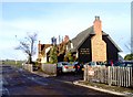
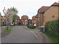
Angel Inn, North Shoebury
Taken at Parson Corner near North Shoebury roundabout looking north towards the only surviving open farmland in the square. This bit of 'The Angel' occupies the long-closed North Shoebury post office. The roadway in front was once part of the A13 which has now been diverted a few yards to the left.
Image: © David Kemp
Taken: 27 Dec 2005
0.08 miles
3
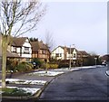
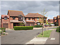
Large family homes, Shoeburyness
Properties such as these are typical of much of this square. The area was open farmland within living memory. Taken in Bishopsteignton looking north-east towards Withypool (whose street sign can be seen behind the car).
This image is as out-of-focus as it is because I had only started digital photography a couple of days before. For a better picture of the same location see Image
Image: © David Kemp
Taken: 27 Dec 2005
0.08 miles
4
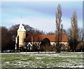
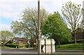
St Mary's Church, North Shoebury
Much of this church dates back to the thirteenth century. Situated beside an extensive green, it represents a rural oasis in an increasingly built-up area. Taken looking north from behind the Asda supermarket.
Image: © David Kemp
Taken: 27 Dec 2005
0.08 miles
5
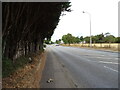
Poynters Lane (B1017) approaching roundabout
Image: © JThomas
Taken: 23 Aug 2022
0.10 miles
7
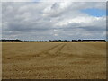
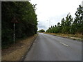
Stubble field, Parson Corner
North of Poynters Lane (B1017)
Image: © JThomas
Taken: 23 Aug 2022
0.14 miles
8
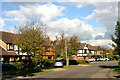
Large family homes, Shoeburyness
Properties such as these are typical of much of this square. The area was open farmland within living memory. Taken in Bishopsteignton looking north-east towards Withypool (whose street sign can be seen in front of the white pick-up truck).
Image: © David Kemp
Taken: 14 Oct 2012
0.14 miles