IMAGES TAKEN NEAR TO
Yarnacott, SOUTHEND-ON-SEA, SS3 8AP
Introduction
This page details the photographs taken nearby to Yarnacott, SS3 8AP by members of the Geograph project.
The Geograph project started in 2005 with the aim of publishing, organising and preserving representative images for every square kilometre of Great Britain, Ireland and the Isle of Man.

There are currently over 7.5m images from over14,400 individuals and you can help contribute to the project by visiting https://www.geograph.org.uk
Image Map (Loading...)


Getting Data...Please wait
Leaflet Map data © OpenStreetMap
Images are licensed for reuse under creativecommons.org/licenses/by-sa/2.0
Notes
- Clicking on the map will re-center to the selected point.
- The higher the marker number, the further away the image location is from the centre of the postcode.
Image Listing (16 Images Found)
Images are licensed for reuse under creativecommons.org/licenses/by-sa/2.0
Image
Details
Distance
1
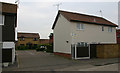
Staplegrove, Shoeburyness
Staplegrove is one of a number of very short cul-de-sacs leading off Aylesbeare.
Image: © David Kemp
Taken: 22 Feb 2018
0.11 miles
2
Abbots Walk, Shoeburyness
Taken at the junction with Bishopsteignton (right).
Image: © David Kemp
Taken: 30 Apr 2020
0.13 miles
3
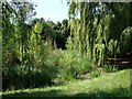
Silted pond
Willow-lined and reed and sedge-choked, a shrinking pond on a small public open space north of the railway line
Image: © John Myers
Taken: 24 Jul 2014
0.14 miles
4
Green at corner of Maplin Way North & Bishopsteignton, Shoeburyness
Image: © David Kemp
Taken: 30 Apr 2020
0.15 miles
5
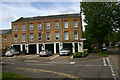
Holsworthy, Shoeburyness
Many of the roads in this gridsquare have for many years been named after places in Devon. However the street sign with its oblong shape and finial is characteristic of Southend alone.
Image: © David Kemp
Taken: 16 Apr 2019
0.16 miles
6
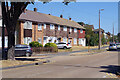
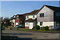
Delaware Road, Shoeburyness
A mixture of terraced houses and flats lines the north side of Delaware Road, seen here from its junction with Blyth Avenue. The housing stock here is obviously local authority built and contrasts noticeably with the private housing to the south.
Image: © Stephen McKay
Taken: 11 Aug 2022
0.17 miles
7
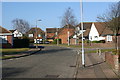
Kingsteignton, Shoeburyness
Taken from the corner of Hawkridge (left). The road on the right is Bickenhall. This area was farmland within living memory but was developed intensively from the late 1970s.
Image: © David Kemp
Taken: 22 Feb 2018
0.17 miles
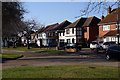
8
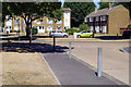
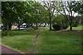
Blyth Avenue/Delaware Road, Shoeburyness
Houses and flats surround a small green on Delaware Road at the northern end of Blyth Avenue. Note the parched brown grass on the verges following a very hot dry spell.
Image: © Stephen McKay
Taken: 11 Aug 2022
0.17 miles
9
Weare Gifford, Shoeburyness
Weare Gifford is a select cul-de-sac off Bishopsteignton.
Image: © David Kemp
Taken: 22 Feb 2018
0.17 miles
10
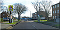
Delaware Road, Shoeburyness
The bus stops are called Thorpedene Library, and are served by route 2, which runs between Southend and Shoeburyness.
Image: © Robin Webster
Taken: 5 Feb 2023
0.18 miles