IMAGES TAKEN NEAR TO
Mucking Hall Road, SOUTHEND-ON-SEA, SS3 0NS
Introduction
This page details the photographs taken nearby to Mucking Hall Road, SS3 0NS by members of the Geograph project.
The Geograph project started in 2005 with the aim of publishing, organising and preserving representative images for every square kilometre of Great Britain, Ireland and the Isle of Man.

There are currently over 7.5m images from over14,400 individuals and you can help contribute to the project by visiting https://www.geograph.org.uk
Image Map (Loading...)


Getting Data...Please wait
Leaflet Map data © OpenStreetMap
Images are licensed for reuse under creativecommons.org/licenses/by-sa/2.0
Notes
- Clicking on the map will re-center to the selected point.
- The higher the marker number, the further away the image location is from the centre of the postcode.
Image Listing (3 Images Found)
Images are licensed for reuse under creativecommons.org/licenses/by-sa/2.0
Image
Details
Distance
1
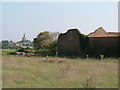
Ruins at New Buildings Farm
A prime example of the folly of calling anything “New!”, these are ruined out buildings at New Buildings Farm. The village in the Background is Barling.
Image: © Glyn Baker
Taken: 16 Oct 2005
0.03 miles
2
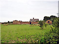
Partly derelict buildings at New Buildings Farm
The brick wall and near buildings surround the largely disused farmyard. The cottages beyond, New Buildings Cottages, are lived in.
Image: © Robin Webster
Taken: 11 Aug 2015
0.06 miles
3
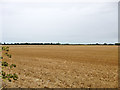
Stubble field
Looking across the flat landscape towards Barling.
Image: © Robin Webster
Taken: 11 Aug 2015
0.19 miles