IMAGES TAKEN NEAR TO
High Street, SOUTHEND-ON-SEA, SS3 0HX
Introduction
This page details the photographs taken nearby to High Street, SS3 0HX by members of the Geograph project.
The Geograph project started in 2005 with the aim of publishing, organising and preserving representative images for every square kilometre of Great Britain, Ireland and the Isle of Man.

There are currently over 7.5m images from over14,400 individuals and you can help contribute to the project by visiting https://www.geograph.org.uk
Image Map (Loading...)


Getting Data...Please wait
Leaflet Map data © OpenStreetMap
Images are licensed for reuse under creativecommons.org/licenses/by-sa/2.0
Notes
- Clicking on the map will re-center to the selected point.
- The higher the marker number, the further away the image location is from the centre of the postcode.
Image Listing (11 Images Found)
Images are licensed for reuse under creativecommons.org/licenses/by-sa/2.0
Image
Details
Distance
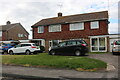
3
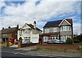
Great Wakering: The Exhibition
241 High Street, Great Wakering. The first of four historical pubs along Wakering high street. We certainly have a choice!
Image: © Julieanne Savage
Taken: 9 Dec 2006
0.11 miles
4
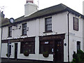
The Exhibition Inn
Pub in the High Street
Image: © John Myers
Taken: 22 Jan 2015
0.13 miles
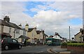
5

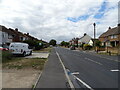
Little Wakering Road, Great Wakering
From the High Street
Image: © David Howard
Taken: 25 May 2021
0.14 miles
6
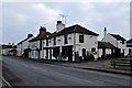
Houses on Southend Road, Great Wakering
Image: © David Howard
Taken: 25 May 2021
0.16 miles
7
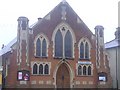
Great Wakering Methodist Church
located on the High Street.
Image: © Julieanne Savage
Taken: 10 Dec 2006
0.20 miles
9
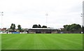
Great Wakering Rovers FC: Burroughs Park
The story of Great Wakering Rovers FC is one of great achievement from humble beginnings. The club was formed in 1919 by demobbed soldiers from the First World War who found employment in the local brickfields. They played in the local Southend leagues for many years until 1989. Since then the club have enjoyed numerous promotions and will play in the Ryman Isthmian League Division 1 North during the forthcoming 2008-2009 season.
The ground seen here was converted from disused allotments and the first competitive match to be played here took place in 1989. The ground is named Burroughs Park after Roger Burroughs, a life-long fan who was instrumental in building the football ground. The club's website is here http://www.greatwakeringroversfc.co.uk/main.htm
Image: © Nigel Cox
Taken: 3 Aug 2008
0.22 miles
10
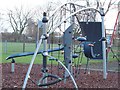
Wakering playground
Next to the Sports Centre.
Image: © Julieanne Savage
Taken: 2 Jan 2007
0.23 miles