IMAGES TAKEN NEAR TO
Estuary Gardens, SOUTHEND-ON-SEA, SS3 0DX
Introduction
This page details the photographs taken nearby to Estuary Gardens, SS3 0DX by members of the Geograph project.
The Geograph project started in 2005 with the aim of publishing, organising and preserving representative images for every square kilometre of Great Britain, Ireland and the Isle of Man.

There are currently over 7.5m images from over14,400 individuals and you can help contribute to the project by visiting https://www.geograph.org.uk
Image Map
Images are licensed for reuse under creativecommons.org/licenses/by-sa/2.0
Notes
- Clicking on the map will re-center to the selected point.
- The higher the marker number, the further away the image location is from the centre of the postcode.
Image Listing (23 Images Found)
Images are licensed for reuse under creativecommons.org/licenses/by-sa/2.0
Image
Details
Distance
1
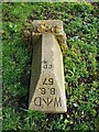
Old Boundary Marker at the end of Victoria Drive
Fallen War Department Boundary Marker at the east end of Victoria Drive, Cupid's Corner. Great Wakering parish. Inscribed W ↑ D / B S / 57 and on the boundary of Shoeburyness New Ranges.
Milestone Society National ID: EX_WDWAK57em
Image: © L Chinea
Taken: 4 Feb 2021
0.08 miles
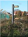
2
Cupids Chase footpath
This is where the Cupids Chase footpath crosses Suttons Road (to which there is no official public access) and heads across MoD land towards Morrin's Point on the coast. When the firing ranges are in use the gates are locked and access is denied.
Image: © David Kemp
Taken: 22 Apr 2019
0.09 miles
3

Footpath from Cupid's Corner to Morrin's Point
Unfortunately, qinetiq are playing with some dangerous toys today so access to the Ranges is restricted and the gate is locked.
Image: © John Myers
Taken: 9 Jan 2015
0.09 miles
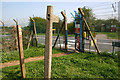
5

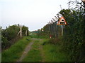
Public Footpath - You Have Been Warned!
The footpath between Great Wakering and the seawall is closed during the week when firing takes place on the army ranges. When, as today, the path is open, walkers are warned of the dangers by an array of notices.
Image: © Trevor Harris
Taken: 28 Feb 2009
0.10 miles
6

Great Wakering: Cupid's Corner: Victoria Drive
Most of the housing development at Cupid's Corner has been post-war, but Victoria Drive was the first estate road to be built and is certainly shown on the Ordnance Survey map of 1938.
Image: © Nigel Cox
Taken: 3 Aug 2008
0.11 miles
7
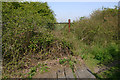
Overgrown railway track near Cupid's Corner
The military area to the east of Shoeburyness was once served by an extensive internal railway system constructed in the late C19 and early C20. The line crossed here is one of the extensions made between 1906-25 and ran across the firing ranges as far as the north shore of Havengore Island. Although the tracks still remain in situ, it would appear that they have not had any trains on them for many years. The path over the level crossing here is the Cupids Chase footpath.
Image: © David Kemp
Taken: 22 Apr 2019
0.14 miles
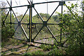
8
Level Crossing Ahead
The public footpath crosses the railway line here.
Image: © Ian Paterson
Taken: 7 May 2008
0.14 miles
9
Gates across disused railway near Cupid's Corner
The military area to the east of Shoeburyness was once served by an extensive internal railway system constructed in the late C19 and early C20. The line crossed here is one of the extensions made between 1906-25 and ran across the firing ranges as far as the north shore of Havengore Island. Although the tracks still remain in situ, it would appear that they have not had any trains on them for many years.
Image: © David Kemp
Taken: 22 Apr 2019
0.14 miles
10

Cupid's Corner 2
At the end of Poynters Lane.
Image: © Julieanne Savage
Taken: 7 Jan 2007
0.16 miles