IMAGES TAKEN NEAR TO
The Common, SOUTHEND-ON-SEA, SS3 0BT
Introduction
This page details the photographs taken nearby to The Common, SS3 0BT by members of the Geograph project.
The Geograph project started in 2005 with the aim of publishing, organising and preserving representative images for every square kilometre of Great Britain, Ireland and the Isle of Man.

There are currently over 7.5m images from over14,400 individuals and you can help contribute to the project by visiting https://www.geograph.org.uk
Image Map
Images are licensed for reuse under creativecommons.org/licenses/by-sa/2.0
Notes
- Clicking on the map will re-center to the selected point.
- The higher the marker number, the further away the image location is from the centre of the postcode.
Image Listing (14 Images Found)
Images are licensed for reuse under creativecommons.org/licenses/by-sa/2.0
Image
Details
Distance
1
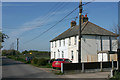
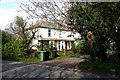
Millhead Cottages, Common Road, Great Wakering
Image: © David Kemp
Taken: 19 Apr 2019
0.01 miles
2
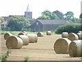
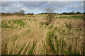
Great Wakering farm
Down Common Road. That is St. Nicholas behind.
Image: © Julieanne Savage
Taken: 15 Jul 2006
0.01 miles
3
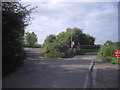
Common Road, Great Wakering
To the left is a track to Mill Barn Coarse Fishery and Little Wakering and to the right the entrance to Wakering Boatyard. Common Road continues ahead until it reaches a security gate beyond which public access to Potton Island is prohibited by the MoD.
Image: © David Kemp
Taken: 30 Apr 2023
0.06 miles
4
Farmland at Wakering Common
Towards Fleet Head.
Image: © Julieanne Savage
Taken: 15 Jul 2006
0.09 miles
5
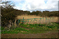
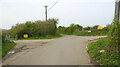
Overgrown footpath at Great Wakering
The vegetation masks an overgrown drainage channel. The path across it is extremely slippery.
Image: © David Kemp
Taken: 17 Mar 2021
0.13 miles
6
Millhead Villas, Common Road, Great Wakering
Image: © David Kemp
Taken: 18 Apr 2019
0.14 miles
7
Scrubland near Mill Head, Great Wakering
Historic OS maps show the scrubland seen here as the site of former brickworks. Taken from the almost indiscernible footpath from Common Road to Mill Head.
Image: © David Kemp
Taken: 17 Mar 2021
0.17 miles
8
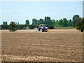
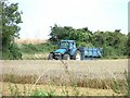
Mowing a dry ditch
Whether this is because a public footpath runs along the field edge or just good husbandry is hard to say. In general this farm takes care of the footpaths on it.
Image: © Robin Webster
Taken: 11 Aug 2015
0.19 miles
9
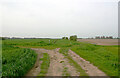
Junction of paths north of Great Wakering
This is where the path from Great Wakering church (foreground) joins a path running right to left from Common Road to Little Wakering.
Image: © David Kemp
Taken: 30 Apr 2023
0.20 miles