IMAGES TAKEN NEAR TO
Radar Close, SOUTHEND-ON-SEA, SS2 6AS
Introduction
This page details the photographs taken nearby to Radar Close, SS2 6AS by members of the Geograph project.
The Geograph project started in 2005 with the aim of publishing, organising and preserving representative images for every square kilometre of Great Britain, Ireland and the Isle of Man.

There are currently over 7.5m images from over14,400 individuals and you can help contribute to the project by visiting https://www.geograph.org.uk
Image Map
Images are licensed for reuse under creativecommons.org/licenses/by-sa/2.0
Notes
- Clicking on the map will re-center to the selected point.
- The higher the marker number, the further away the image location is from the centre of the postcode.
Image Listing (8 Images Found)
Images are licensed for reuse under creativecommons.org/licenses/by-sa/2.0
Image
Details
Distance
4
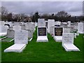
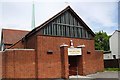
Jewish Cemetery
On Stock Road. The Industrial estate is behind it.
Image: © Julieanne Savage
Taken: 11 Jan 2006
0.16 miles
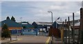
6
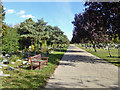
Road in Sutton Road Cemetery
A large, cosmopolitan cemetery.
Image: © Robin Webster
Taken: 1 Oct 2018
0.24 miles
7
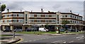
Manners Court, Southend-On-Sea
1930's Shopping Arcade, with Flats.
Image: © Jamie Collins
Taken: 14 Jul 2007
0.24 miles