IMAGES TAKEN NEAR TO
Stock Road, SOUTHEND-ON-SEA, SS2 5XB
Introduction
This page details the photographs taken nearby to Stock Road, SS2 5XB by members of the Geograph project.
The Geograph project started in 2005 with the aim of publishing, organising and preserving representative images for every square kilometre of Great Britain, Ireland and the Isle of Man.

There are currently over 7.5m images from over14,400 individuals and you can help contribute to the project by visiting https://www.geograph.org.uk
Image Map
Images are licensed for reuse under creativecommons.org/licenses/by-sa/2.0
Notes
- Clicking on the map will re-center to the selected point.
- The higher the marker number, the further away the image location is from the centre of the postcode.
Image Listing (22 Images Found)
Images are licensed for reuse under creativecommons.org/licenses/by-sa/2.0
Image
Details
Distance
2
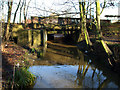
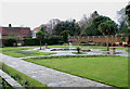
Prittle Brook
This culvert carries Prittle Brook out of Priory Park and under Priory Crescent.
Image: © terry joyce
Taken: 18 Jan 2011
0.11 miles
3
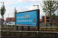
Advertising sign for Aldi Southend-on-Sea
Image: © David Howard
Taken: 25 May 2021
0.14 miles
6
Aldi on Priory Crescent, Prittlewell
The map shows a blank space here, but the flats arrived in 2009. I don't know what was there before.
Image: © David Howard
Taken: 25 May 2021
0.15 miles
7
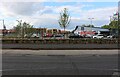
Development site - no more flexible friend
North of Priory Park is this development site. From 1972 this area housed the offices of Access (credit card)- slogan "Your flexible friend".
Image: © Trevor Harris
Taken: 18 Mar 2014
0.16 miles
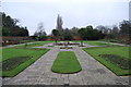
8
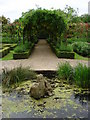
Walled Garden
This is the walled garden in Priory Park, Prittlewell, Southend-on-Sea. The Priory can be seen in the background.
Image: © terry joyce
Taken: 10 Jan 2011
0.18 miles
9
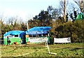
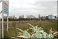
Camp Bling, Priory Crescent, Southend-on-Sea
In 2003 a Saxon burial chamber containing a number of treasures was discovered on this site which lies between Priory Crescent and the railway. Camp Bling was established in 2005 as a protest against a road-widening scheme which will in due course cover the site together with a section of nearby Priory Park.
Image: © David Kemp
Taken: 20 Jan 2006
0.18 miles
10
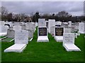
Jewish Cemetery
On Stock Road. The Industrial estate is behind it.
Image: © Julieanne Savage
Taken: 11 Jan 2006
0.19 miles