IMAGES TAKEN NEAR TO
Chandlers Way, SOUTHEND-ON-SEA, SS2 5SE
Introduction
This page details the photographs taken nearby to Chandlers Way, SS2 5SE by members of the Geograph project.
The Geograph project started in 2005 with the aim of publishing, organising and preserving representative images for every square kilometre of Great Britain, Ireland and the Isle of Man.

There are currently over 7.5m images from over14,400 individuals and you can help contribute to the project by visiting https://www.geograph.org.uk
Image Map
Images are licensed for reuse under creativecommons.org/licenses/by-sa/2.0
Notes
- Clicking on the map will re-center to the selected point.
- The higher the marker number, the further away the image location is from the centre of the postcode.
Image Listing (12 Images Found)
Images are licensed for reuse under creativecommons.org/licenses/by-sa/2.0
Image
Details
Distance
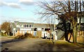
3
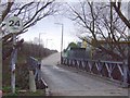
West end of Sumpters Way
No through road - for traffic at least - as this is the entry to the sports clubs and playing fields. Turn right after crossing the bridge if you are on foot as it saves a long walk to the airport.
See Image for the opposite view.
Image: © Ian Paterson
Taken: 9 Jun 2016
0.09 miles
4

Old Man Willow
Old Man Willow is a stunning specimen that grows in the brook running through Warner's Bridge Park. He overlooks the Old Southendians next door.
Image: © Julieanne Savage
Taken: 11 Jan 2006
0.10 miles
5
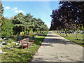
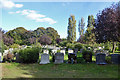
Road in Sutton Road Cemetery
A large, cosmopolitan cemetery.
Image: © Robin Webster
Taken: 1 Oct 2018
0.13 miles
6
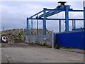
Temple Farm Industrial Estate, Southend
This gridsquare comprises part of a large cemetery, some open farmland and Temple Farm Industrial Estate. This photograph shows the latter at the junction of The Wheelwrights and Craftsmans Square looking north-east.
Image: © David Kemp
Taken: 9 Feb 2006
0.15 miles
7
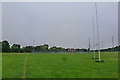
Playing fields and shortcut
General view of the playing fields taken from the north-western point of the site. The shortcut to the industrial estate is well marked on the left.
Image: © Ian Paterson
Taken: 9 Jun 2016
0.21 miles
8
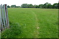
Shortcut from Southend Road to Industrial Estate
To save walking 2.5 miles along the roads from the Airport to the Industrial Estate, why not take the shortcut across the playing fields instead? It's well marked out and easier on the legs.
Image: © Ian Paterson
Taken: 9 Jun 2016
0.23 miles
9
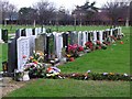
New graves
These graves at Sutton Road cemetery are seem to be new additions. There are two fields at the back for recent graves. I took them from the side so we couldn't see the names on the headstones. You can see the industrial estate and offices behind.
Image: © Julieanne Savage
Taken: 11 Jan 2006
0.23 miles
10
In Sutton Road Cemetery
A large, cosmopolitan cemetery.
Image: © Robin Webster
Taken: 1 Oct 2018
0.24 miles