IMAGES TAKEN NEAR TO
Royston Avenue, SOUTHEND-ON-SEA, SS2 5JX
Introduction
This page details the photographs taken nearby to Royston Avenue, SS2 5JX by members of the Geograph project.
The Geograph project started in 2005 with the aim of publishing, organising and preserving representative images for every square kilometre of Great Britain, Ireland and the Isle of Man.

There are currently over 7.5m images from over14,400 individuals and you can help contribute to the project by visiting https://www.geograph.org.uk
Image Map
Images are licensed for reuse under creativecommons.org/licenses/by-sa/2.0
Notes
- Clicking on the map will re-center to the selected point.
- The higher the marker number, the further away the image location is from the centre of the postcode.
Image Listing (24 Images Found)
Images are licensed for reuse under creativecommons.org/licenses/by-sa/2.0
Image
Details
Distance
1
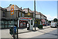
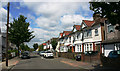
Parade of shops, Sutton Road, Southend-on-Sea (2)
Image: © David Kemp
Taken: 19 Jun 2018
0.05 miles
2
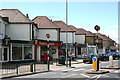
Parade of shops, Sutton Road, Southend-on-Sea (1)
Image: © David Kemp
Taken: 19 Jun 2018
0.06 miles
3

Terriers Home
This is the Southend base for the Territorial Army (Army reserves in modern parlance). It is the local H.Q for the Army Cadets and should you come across a U.X.B in your back garden the Royal Engineers 217 Field Squadron Explosive Ordnance Disposal are here too.
Image: © Glyn Baker
Taken: 20 Aug 2019
0.07 miles
4

Victoria Sports Ground Gates
High Victorian ironwork, the park has free access for anyone wishing to walk in a green lung in the suburban sprawl of Southend.
Image: © Glyn Baker
Taken: 20 Aug 2019
0.08 miles
5

Entrance to Victory Sports Ground, Southend-on-Sea
These ornamental gates are comparable to the gates at the entrance to the Jones Memorial Recreation Ground nearby Image both being having been sponsored by local benefactor R A Jones. The victory in question was that of this country and its allies in World War I.
Image: © David Kemp
Taken: 19 Jun 2018
0.09 miles
8
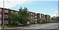
The Mulberrys, Southend-on-Sea
The Mulberrys is a group of low-rise flats in Sutton Road near the Eastern Avenue roundabout.
Image: © David Kemp
Taken: 19 Jun 2018
0.16 miles
9
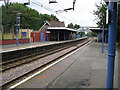
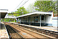
Prittlewell railway station
The Great Eastern Railway opened their branch line from London Liverpool Street to Southend via Shenfield in 1889 and Prittlewell station was opened three years later in 1892. At that time Prittlewell was a distinct village, whereas today it has been swallowed up in the urban sprawl of Southend.
The gentleman sat on the bench on the opposite platform is in for a long wait. This is Sunday, no trains stop and the next departure towards Rochford is at the nonetheless remarkably early time of 0404 hours on Monday morning...
Image: © Nigel Cox
Taken: 3 Aug 2008
0.20 miles