IMAGES TAKEN NEAR TO
Castleton Road, SOUTHEND-ON-SEA, SS2 4UF
Introduction
This page details the photographs taken nearby to Castleton Road, SS2 4UF by members of the Geograph project.
The Geograph project started in 2005 with the aim of publishing, organising and preserving representative images for every square kilometre of Great Britain, Ireland and the Isle of Man.

There are currently over 7.5m images from over14,400 individuals and you can help contribute to the project by visiting https://www.geograph.org.uk
Image Map
Images are licensed for reuse under creativecommons.org/licenses/by-sa/2.0
Notes
- Clicking on the map will re-center to the selected point.
- The higher the marker number, the further away the image location is from the centre of the postcode.
Image Listing (44 Images Found)
Images are licensed for reuse under creativecommons.org/licenses/by-sa/2.0
Image
Details
Distance
1
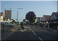
Hamstel Road at the junction of Poynings Avenue
Image: © David Howard
Taken: 24 May 2012
0.09 miles
4
Central Avenue
Central Avenue is one-way eastwards, parallel roads North Avenue and South Avenue are one-way westwards.
Image: © Robin Webster
Taken: 1 Oct 2018
0.16 miles
5
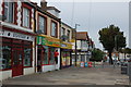
Shops in Hamstel Road
Looking north towards its junction with North Avenue.
Image: © Trevor Harris
Taken: 12 Oct 2014
0.17 miles
6
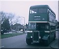
Preserved Bus at Southchurch Boulevard
Taken in April 1973, this bus was on a tour of the former trolleybus system in Southend-on-Sea which closed on the 28th October 1954. It is shown at the West end of Southchurch Boulevard which was served by trolleybus route 63A/B which went via Southchurch Road, Hamstel Road and North Avenue. The vehicle shown is 55 (EHO 228) a 1942 Guy Arab II with Reading 56-seater bodywork built in 1955 and used to operate with Provincial (Gosport & Fareham Omnibus Co.Ltd).
Image: © David Hillas
Taken: 15 Apr 1973
0.20 miles
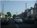
7

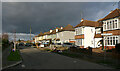
Arlington Road, Southend - north end, east side
The northern part of Arlington Road is mainly bungalows whereas the southern part contains a mixture of detached properties and large semis.
Image: © David Kemp
Taken: 27 Jan 2023
0.20 miles
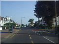
8
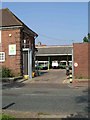
Milk Floats in Southchurch
This is the Dairy Crest milk float depot in Southchurch. The road in front is the eastbound carriageway of the A13
Image: © Glyn Baker
Taken: 16 Oct 2005
0.20 miles
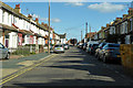
9
Arlington Road, Southend - east side
Taken at the junction with Pelham Road (left).
Image: © David Kemp
Taken: 27 Jan 2023
0.20 miles
10

Arlington Road & Poynings Avenue, Southend
Image: © David Kemp
Taken: 27 Jan 2023
0.20 miles