IMAGES TAKEN NEAR TO
Canterbury Avenue, SOUTHEND-ON-SEA, SS2 4QL
Introduction
This page details the photographs taken nearby to Canterbury Avenue, SS2 4QL by members of the Geograph project.
The Geograph project started in 2005 with the aim of publishing, organising and preserving representative images for every square kilometre of Great Britain, Ireland and the Isle of Man.

There are currently over 7.5m images from over14,400 individuals and you can help contribute to the project by visiting https://www.geograph.org.uk
Image Map
Images are licensed for reuse under creativecommons.org/licenses/by-sa/2.0
Notes
- Clicking on the map will re-center to the selected point.
- The higher the marker number, the further away the image location is from the centre of the postcode.
Image Listing (13 Images Found)
Images are licensed for reuse under creativecommons.org/licenses/by-sa/2.0
Image
Details
Distance
1
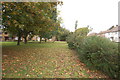
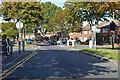
Green on Archer Avenue
An attractive green area in the housing estate.
Image: © Trevor Harris
Taken: 12 Oct 2014
0.10 miles
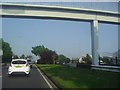
2
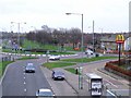
View from the Bridge
Here you see the busy dual carriageway coming onto Eastern Avenue, Southend-on-Sea. A drive-through McDonald's is on the left on the corner of Hamstel Road. I took the photo looking down from the bridge across Eastern Avenue.
Image: © Julieanne Savage
Taken: 9 Jan 2007
0.14 miles
3
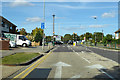
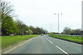
Hamstel Road
Heading north towards the roundabout on the A1159.
Image: © Robin Webster
Taken: 1 Oct 2018
0.14 miles
4
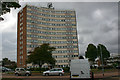
Longbow, Sherwood Way, Southend
Longbow was completed in 1964.
Image: © David Kemp
Taken: 8 Oct 2016
0.15 miles
6
Royal Artillery Way, heading east
Towards Shoeburyness, a former garrison town, hence the name of the road.
Image: © Robin Webster
Taken: 6 Apr 2018
0.17 miles
7
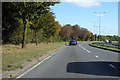
A1159, Royal Artillery Way, heading east
Towards Shoeburyness, a former garrison town, hence the name of the road.
Image: © Robin Webster
Taken: 1 Oct 2018
0.17 miles
8
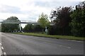
Footbridge over Eastern Avenue, Southend
Garon Park is on the right
Image: © David Howard
Taken: 25 May 2021
0.21 miles
9
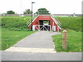
Red Underpass
This underpass goes under Royal Artillery Way and lead to the byway that goes to Rebels Lane and also other footpaths.
Image: © terry joyce
Taken: 31 Aug 2011
0.22 miles
10
Footbridge over Eastern Avenue, Southchurch
Image: © David Howard
Taken: 24 May 2012
0.22 miles