IMAGES TAKEN NEAR TO
Lonsdale Road, SOUTHEND-ON-SEA, SS2 4LZ
Introduction
This page details the photographs taken nearby to Lonsdale Road, SS2 4LZ by members of the Geograph project.
The Geograph project started in 2005 with the aim of publishing, organising and preserving representative images for every square kilometre of Great Britain, Ireland and the Isle of Man.

There are currently over 7.5m images from over14,400 individuals and you can help contribute to the project by visiting https://www.geograph.org.uk
Image Map
Images are licensed for reuse under creativecommons.org/licenses/by-sa/2.0
Notes
- Clicking on the map will re-center to the selected point.
- The higher the marker number, the further away the image location is from the centre of the postcode.
Image Listing (11 Images Found)
Images are licensed for reuse under creativecommons.org/licenses/by-sa/2.0
Image
Details
Distance
1
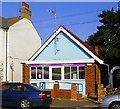
Connexions Youth Centre
A converted church, now performing as a youth centre, Stornoway Road, Southend.
Image: © Paul Collins
Taken: 21 Sep 2008
0.07 miles
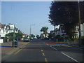
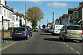
2
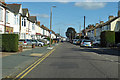
Central Avenue
Central Avenue is one-way eastwards, parallel roads North Avenue and South Avenue are one-way westwards.
Image: © Robin Webster
Taken: 1 Oct 2018
0.12 miles
3
Central Avenue
Central Avenue is one-way eastwards, parallel roads North Avenue and South Avenue are one-way westwards.
Image: © Robin Webster
Taken: 1 Oct 2018
0.12 miles
4
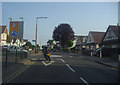
Hamstel Road at the junction of Poynings Avenue
Image: © David Howard
Taken: 24 May 2012
0.14 miles
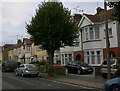
5
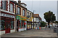
Shops in Hamstel Road
Looking north towards its junction with North Avenue.
Image: © Trevor Harris
Taken: 12 Oct 2014
0.18 miles
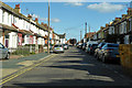
7
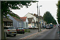
South Avenue, Southend - south side
South Avenue along with Central Avenue and North Avenue form a trio of long and unimaginatively named roads linking Hamstel Road, Bournemouth Park Road and Sutton Road. It is however notable for its variety of terraced and single-storey housing suggesting the piecemeal development of a series of small plots. This shows the section between Westbury Avenue and Lyme Road.
Image: © David Kemp
Taken: 26 Sep 2020
0.21 miles
9
Central Avenue
Central Avenue is one-way eastwards, parallel roads North Avenue and South Avenue are one-way westwards.
Image: © Robin Webster
Taken: 1 Oct 2018
0.24 miles
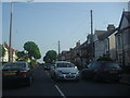
10
South Avenue, Southend - north side
South Avenue along with Central Avenue and North Avenue is part of a trio of long and unimaginatively named roads linking Hamstel Road, Bournemouth Park Road and Sutton Road. It is however notable for its variety of terraced housing suggesting the piecemeal development of a series of small plots.
Image: © David Kemp
Taken: 26 Sep 2020
0.24 miles