IMAGES TAKEN NEAR TO
Trinity Road, SOUTHEND-ON-SEA, SS2 4HL
Introduction
This page details the photographs taken nearby to Trinity Road, SS2 4HL by members of the Geograph project.
The Geograph project started in 2005 with the aim of publishing, organising and preserving representative images for every square kilometre of Great Britain, Ireland and the Isle of Man.

There are currently over 7.5m images from over14,400 individuals and you can help contribute to the project by visiting https://www.geograph.org.uk
Image Map
Images are licensed for reuse under creativecommons.org/licenses/by-sa/2.0
Notes
- Clicking on the map will re-center to the selected point.
- The higher the marker number, the further away the image location is from the centre of the postcode.
Image Listing (11 Images Found)
Images are licensed for reuse under creativecommons.org/licenses/by-sa/2.0
Image
Details
Distance
1
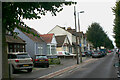
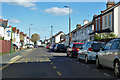
South Avenue, Southend - south side
South Avenue along with Central Avenue and North Avenue form a trio of long and unimaginatively named roads linking Hamstel Road, Bournemouth Park Road and Sutton Road. It is however notable for its variety of terraced and single-storey housing suggesting the piecemeal development of a series of small plots. This shows the section between Westbury Avenue and Lyme Road.
Image: © David Kemp
Taken: 26 Sep 2020
0.04 miles
2
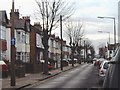
South Avenue, Southend - north side
South Avenue along with Central Avenue and North Avenue is part of a trio of long and unimaginatively named roads linking Hamstel Road, Bournemouth Park Road and Sutton Road. It is however notable for its variety of terraced housing suggesting the piecemeal development of a series of small plots.
Image: © David Kemp
Taken: 26 Sep 2020
0.05 miles
3
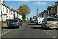
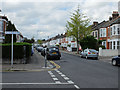
Central Avenue
Central Avenue is one-way eastwards, parallel roads North Avenue and South Avenue are one-way westwards.
Image: © Robin Webster
Taken: 1 Oct 2018
0.09 miles
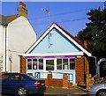
4
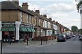
The Oban Fish Shop
Founded in 1948 at the junction of Oban and Stornoway Roads
Image: © Glyn Baker
Taken: 20 Aug 2019
0.09 miles
5
Central Avenue at The Grove bus stop
The Grove is a crossing road just behind the camera. Central Avenue is one-way eastwards, parallel roads North Avenue and South Avenue are one-way westwards.
Image: © Robin Webster
Taken: 1 Oct 2018
0.10 miles
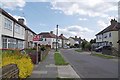
6
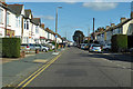
North Avenue, Southend-on-Sea
North Avenue, now a one-way street, was served until 1954 by Southend Corporation's East Circular trolleybus route which provided six buses per hour in each direction into the town centre and from there to Westcliff Image To the south is a dense grid of similar streets and to the north a post-War council estate. Taken just west of Westbury Road looking west.
Image: © David Kemp
Taken: 27 Jan 2006
0.12 miles
7
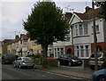
Christchurch Road
Seen from its junction with Boscombe Road.
Image: © John Allan
Taken: 15 May 2013
0.16 miles
8
Central Avenue
Central Avenue is one-way eastwards, parallel roads North Avenue and South Avenue are one-way westwards.
Image: © Robin Webster
Taken: 1 Oct 2018
0.17 miles
9
Norwich Avenue & The Grove
Norwich Ave bears off to the left.
Image: © Glyn Baker
Taken: 20 Aug 2019
0.23 miles
10
Connexions Youth Centre
A converted church, now performing as a youth centre, Stornoway Road, Southend.
Image: © Paul Collins
Taken: 21 Sep 2008
0.23 miles