IMAGES TAKEN NEAR TO
Eastern Avenue, SOUTHEND-ON-SEA, SS2 4BU
Introduction
This page details the photographs taken nearby to Eastern Avenue, SS2 4BU by members of the Geograph project.
The Geograph project started in 2005 with the aim of publishing, organising and preserving representative images for every square kilometre of Great Britain, Ireland and the Isle of Man.

There are currently over 7.5m images from over14,400 individuals and you can help contribute to the project by visiting https://www.geograph.org.uk
Image Map
Images are licensed for reuse under creativecommons.org/licenses/by-sa/2.0
Notes
- Clicking on the map will re-center to the selected point.
- The higher the marker number, the further away the image location is from the centre of the postcode.
Image Listing (19 Images Found)
Images are licensed for reuse under creativecommons.org/licenses/by-sa/2.0
Image
Details
Distance
1
View from the Bridge 2
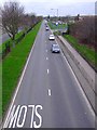
This is the extremely busy A1159, known as Eastern Avenue in Southend-on-Sea. This part of the dual carriageway has a long central reservation lined with mature horse chestnut trees and the area is full of conkers in Autumn, eagerly collected by the students who attend the school here. You can see the entrance to Cecil Jones College on the left here behind the white car. I was standing on the school bridge taking the photograph.
Image: © Julieanne Savage
Taken: 9 Jan 2007
0.13 miles
2
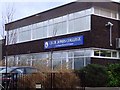
Cecil Jones College
On Eastern Avenue
Image: © Julieanne Savage
Taken: 9 Jan 2007
0.13 miles
3
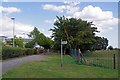
Incognito Footpath
This path appears on the O.S maps. It runs from the A127 to the Image but is absent from Essex County Council's Electronic Public Right of Way website https://www.essexhighways.org/getting-around/public-rights-of-way/prow-interactive-map.aspx
Image: © Glyn Baker
Taken: 20 Aug 2019
0.16 miles
4
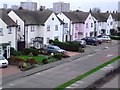
Eastern Avenue
The houses on this busy road are set back, along a little slipway. These houses are next to McDonald's and are on the left hand side of the road, London bound.
Image: © Julieanne Savage
Taken: 9 Jan 2007
0.16 miles
5
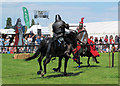
Jousting knights
Display of medieval combat at Garon Park country show.
Image: © william
Taken: 2 Jul 2011
0.16 miles
6
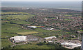
Fossetts Way and beyond
Lots to see. The large building bottom left is B&Q. Waitrose bottom right.
These are located on Fossetts Way. The red track is part of Garons Leisure Centre.
Image: © terry joyce
Taken: 22 Jun 2008
0.17 miles
8
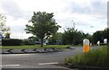
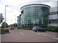
Roundabout on Royal Artillery Way, Southend
Image: © David Howard
Taken: 25 May 2021
0.17 miles
9
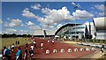
Southend Leisure & Tennis Centre, Garon Park
This is the entrance of the Centre which is run by Creating Leisure on behalf of Southend Borough Council. The centre's website is here http://www.creating-leisure.co.uk/centredetails.php?RECORD_KEY(centres)=ID&ID(centres)=55 The bus, which is at the eastern terminus of its route, is a First No. 27 bound for Canvey
Image: © Nigel Cox
Taken: 22 Jun 2007
0.17 miles
10
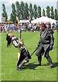
Death on two legs
Display of medieval combat at Garon Park show.
Image: © william
Taken: 2 Jul 2011
0.18 miles