IMAGES TAKEN NEAR TO
St. Lukes Road, SOUTHEND-ON-SEA, SS2 4AG
Introduction
This page details the photographs taken nearby to St. Lukes Road, SS2 4AG by members of the Geograph project.
The Geograph project started in 2005 with the aim of publishing, organising and preserving representative images for every square kilometre of Great Britain, Ireland and the Isle of Man.

There are currently over 7.5m images from over14,400 individuals and you can help contribute to the project by visiting https://www.geograph.org.uk
Image Map
Images are licensed for reuse under creativecommons.org/licenses/by-sa/2.0
Notes
- Clicking on the map will re-center to the selected point.
- The higher the marker number, the further away the image location is from the centre of the postcode.
Image Listing (7 Images Found)
Images are licensed for reuse under creativecommons.org/licenses/by-sa/2.0
Image
Details
Distance
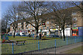
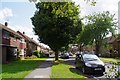
2
St. Luke's Road
Passing Cluny Square recreation ground on the left.
Image: © Robin Webster
Taken: 1 Oct 2018
0.09 miles
3
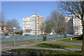
Blocks of flats, Norwich Avenue, Southend-on-Sea
Temple House is on the left and Sutton House on the right and both are in Norwich Avenue. The area is known as 'Temple Sutton' but I am not sure whether it got its name from the flats or vice versa. Taken from the south-west corner of Cluny Square.
Image: © David Kemp
Taken: 2 Apr 2013
0.12 miles
4
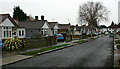
Lyndale Avenue, Southend-on-Sea
A quiet road of pre-War bungalows in Southchurch.
Image: © David Kemp
Taken: 22 Feb 2021
0.13 miles
5
St Luke's Rd
Part of an extensive 1950s/60s former council house development.
Image: © Glyn Baker
Taken: 20 Aug 2019
0.14 miles
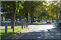
6
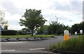
Roundabout on Royal Artillery Way, Southend
Image: © David Howard
Taken: 25 May 2021
0.17 miles
7
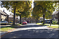
St. Luke's Road
A right bend ahead, in this estate of nested crescents.
Image: © Robin Webster
Taken: 1 Oct 2018
0.22 miles