IMAGES TAKEN NEAR TO
Woodview, BASILDON, SS16 6TZ
Introduction
This page details the photographs taken nearby to Woodview, SS16 6TZ by members of the Geograph project.
The Geograph project started in 2005 with the aim of publishing, organising and preserving representative images for every square kilometre of Great Britain, Ireland and the Isle of Man.

There are currently over 7.5m images from over14,400 individuals and you can help contribute to the project by visiting https://www.geograph.org.uk
Image Map (Loading...)


Getting Data...Please wait
Leaflet Map data © OpenStreetMap
Images are licensed for reuse under creativecommons.org/licenses/by-sa/2.0
Notes
- Clicking on the map will re-center to the selected point.
- The higher the marker number, the further away the image location is from the centre of the postcode.
Image Listing (8 Images Found)
Images are licensed for reuse under creativecommons.org/licenses/by-sa/2.0
Image
Details
Distance
2
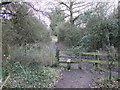
Stile on path in Langdon nature reserve
Image: © PAUL FARMER
Taken: 21 Jan 2012
0.17 miles
3
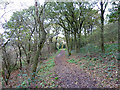
Bridleway, Langdon Nature Reserve
This seems to be in the Langdon Lake and Meadows part of the reserve, but resembles neither!
Image: © Robin Webster
Taken: 13 Nov 2010
0.19 miles
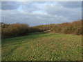
5
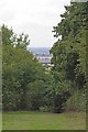
#8 First Avenue View
During the Blitz exactly 70 years before this photo was taken there were no tall trees here. The Plotland owners could clearly see their City being bombed. Today on the horizon through the gap in the trees the towers on Isle of Dogs can be clearly seen. Although much safer than the East End bombs did fall on Dunton during ww2 with fatal consequences. For more information on the Dunton Plotlands see http://www.basildon.com/history/dunton/plotland.html the area is now a Nature Reserve owned by Essex Wildlife Trust http://www.essexwt.org.uk/visitor_centres__nature_reserves/langdon/ To continue on a virtual tour based the Plotlands Walk (copies available currently for 75p from
Image ) go to Image
Image: © Glyn Baker
Taken: 4 Sep 2010
0.20 miles
6
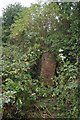
#7 Falling Fireplace
This ruin is in Hillcrest Avenue. Under the brambles the mossy lumps are the timber footings of "Viewgrand" demolished in 1985. For more information on the Dunton Plotlands see http://www.basildon.com/history/dunton/plotland.html the area is now a Nature Reserve owned by Essex Wildlife Trust http://www.essexwt.org.uk/visitor_centres__nature_reserves/langdon/ To continue on a virtual tour based the Plotlands Walk (copies available currently for 75p from Image )
go to Image
Image: © Glyn Baker
Taken: 4 Sep 2010
0.21 miles
7
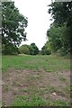
# 6 Hillcrest Avenue
Looking along Hillcrest Avenue one can clearly see the remains of ridges and furrows caused by many years of ploughing before plots were sold off before WW2 for holiday homes. However these features are difficult to show in a two dimensional photo. For more information on the Dunton Plotlands see http://www.basildon.com/history/dunton/plotland.html the area is now a Nature Reserve owned by Essex Wildlife Trust http://www.essexwt.org.uk/visitor_centres__nature_reserves/langdon/ To continue on a virtual tour based the Plotlands Walk (copies available currently for 75p from
Image ) go to Image
Image: © Glyn Baker
Taken: 4 Sep 2010
0.22 miles
8
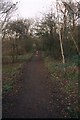
Dunton Plotlands
Path running parallel to Hilcrest Avenue
Image: © Paul Francis
Taken: 2 Mar 2000
0.23 miles