IMAGES TAKEN NEAR TO
Coburg Lane, BASILDON, SS16 6TH
Introduction
This page details the photographs taken nearby to Coburg Lane, SS16 6TH by members of the Geograph project.
The Geograph project started in 2005 with the aim of publishing, organising and preserving representative images for every square kilometre of Great Britain, Ireland and the Isle of Man.

There are currently over 7.5m images from over14,400 individuals and you can help contribute to the project by visiting https://www.geograph.org.uk
Image Map
Images are licensed for reuse under creativecommons.org/licenses/by-sa/2.0
Notes
- Clicking on the map will re-center to the selected point.
- The higher the marker number, the further away the image location is from the centre of the postcode.
Image Listing (21 Images Found)
Images are licensed for reuse under creativecommons.org/licenses/by-sa/2.0
Image
Details
Distance
2
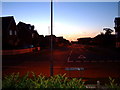
Denehurst Gardens, Great Berry, Laindon
Image: © John Winfield
Taken: 16 Sep 2005
0.11 miles
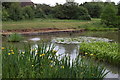
4
Flower-rich meadow at the Langdon Reserve
The Essex Wildlife Trust's http://www.essexwt.org.uk/visitor_centres__nature_reserves/langdon/ Langdon reserve is at the southern fringes of an extensive housing development, some of which is visible in the distance. The reserve comprises a mix of scrubby plotlands, flower-rich meadows (such as this) and woodland.
Image: © John Rostron
Taken: Unknown
0.13 miles
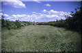
6
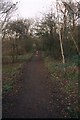
Dunton Plotlands
Path running parallel to Hilcrest Avenue
Image: © Paul Francis
Taken: 2 Mar 2000
0.14 miles
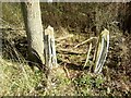
9
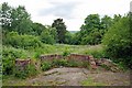
Ruined Hawthorn in Dunton Plotlands
This is the ruin of “Hawthorn” which was one of the Dunton Plotland dwellings.
You can see the last survivor of them at Image For more info see http://www.basildon.com/history/dunton/plotland.html the whole area is now in the care of Essex Wildlife Trust see http://www.essexwt.org.uk/visitor_centres__nature_reserves/langdon/
Continue on a virtual tour of Wildlife Trust Reserves in Essex by visiting Image
Image: © Glyn Baker
Taken: 7 Jun 2009
0.16 miles
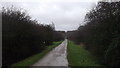
10
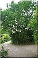
# 5 "Hawthorn Plot"
This is the junction of Third Avenue and Hillcrest Avenue the oak tree was planted as a boundary marker for the “Hawthorn” plot. You can see the remains of the house at Image For more information on the Dunton Plotlands see http://www.basildon.com/history/dunton/plotland.html the area is now a Nature Reserve owned by Essex Wildlife Trust http://www.essexwt.org.uk/visitor_centres__nature_reserves/langdon/ To continue on a virtual tour based the Plotlands Walk (copies available currently for 75p from Image ) go to Image
Image: © Glyn Baker
Taken: 4 Sep 2010
0.16 miles