IMAGES TAKEN NEAR TO
Dalmeny, BASILDON, SS16 6DD
Introduction
This page details the photographs taken nearby to Dalmeny, SS16 6DD by members of the Geograph project.
The Geograph project started in 2005 with the aim of publishing, organising and preserving representative images for every square kilometre of Great Britain, Ireland and the Isle of Man.

There are currently over 7.5m images from over14,400 individuals and you can help contribute to the project by visiting https://www.geograph.org.uk
Image Map
Images are licensed for reuse under creativecommons.org/licenses/by-sa/2.0
Notes
- Clicking on the map will re-center to the selected point.
- The higher the marker number, the further away the image location is from the centre of the postcode.
Image Listing (12 Images Found)
Images are licensed for reuse under creativecommons.org/licenses/by-sa/2.0
Image
Details
Distance
2
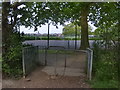
Anyone for tennis?
Tennis courts and further back, the children's playground and football pitches in Lincewood Recreation Ground.
Image: © William Metcalfe
Taken: 25 Apr 2007
0.15 miles
3
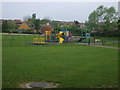
Lincewood playground
Children's play area in Lincewood Recreation Ground,
Image: © William Metcalfe
Taken: 25 Apr 2007
0.16 miles
4
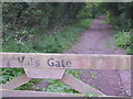
Val's Gate
A memorial gate to a countryside lover, leading from the recreation ground uphill to a bridleway in the Langdon nature reserve.
Image: © William Metcalfe
Taken: 25 Apr 2007
0.16 miles
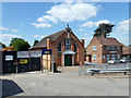
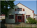
6
St. Mary's Church Hall, Langdon Hills, near Laindon
St. Mary's Church Hall at Langdon Hills, on the outskirts of Basildon.
Image: © Malc McDonald
Taken: 27 Aug 2017
0.19 miles
7
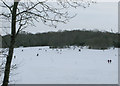
Langdon Hills recreation ground cricket pitch in snow
This is the view looking from the bottom of the hill across the cricket pitch towards the top of the hill. Image taken Jan 2010. Every time it snows crowds of people come from the surrounding private housing estates that surround 'The Rec' to sledge and have fun in the snow. The cricket pitch as you can see is respected and it's fence remains in place all year and it's rarely encroached upon. The Rec has a disused tarmac tennis court with basket ball hoops, a football pitch and an enclosed children's playground. The cricket pitch is used by Basildon and Pitsea Cricket Club and Westleigh Heights Cricket Club.
Image: © someblokecalleddave
Taken: 9 Jan 2010
0.21 miles
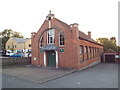
8
Langdon Hills Methodist Church
The church is at the end of Emanuel Road. A foundation stone dated 1909, reinforces that this is one of the oldest parts of Laindon and Langdon Hills, pre-dating the New Town by over 50 years. Many of the houses here are bungalows.
Image: © William Metcalfe
Taken: 28 Apr 2007
0.21 miles
9
Laindon Baptist Church
One of five churches within a few hundred yards along Laindon High Road.
Image: © William Metcalfe
Taken: 28 Apr 2007
0.21 miles
10
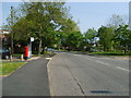
Laindon High Road
View towards Laindon Station from its junction with Valance Way.
Image: © William Metcalfe
Taken: 28 Apr 2007
0.21 miles