IMAGES TAKEN NEAR TO
Fletchers, BASILDON, SS16 5TU
Introduction
This page details the photographs taken nearby to Fletchers, SS16 5TU by members of the Geograph project.
The Geograph project started in 2005 with the aim of publishing, organising and preserving representative images for every square kilometre of Great Britain, Ireland and the Isle of Man.

There are currently over 7.5m images from over14,400 individuals and you can help contribute to the project by visiting https://www.geograph.org.uk
Image Map
Images are licensed for reuse under creativecommons.org/licenses/by-sa/2.0
Notes
- Clicking on the map will re-center to the selected point.
- The higher the marker number, the further away the image location is from the centre of the postcode.
Image Listing (6 Images Found)
Images are licensed for reuse under creativecommons.org/licenses/by-sa/2.0
Image
Details
Distance
1
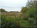
Recently fenced field
A curious choice of fencing, as if horses are to be confined here. It is certainly no significant impediment to entry. However, the sign says "Private Land No public access or right of way". The body indicated on the sign is the Homes and Communities Agency.
Image: © Robin Webster
Taken: 13 Nov 2010
0.17 miles
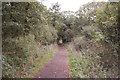
2

Bridleway
Bridleway in Willow Park, also part of Route 13 on the National Cycle Network. Part of the 600 acre Langdon Nature Reserve, situated about a mile from the centre of Basildon.
Image: © William Metcalfe
Taken: 18 Apr 2007
0.18 miles
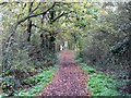
3
Bridle path
In Willow Park nature Reserve.
Image: © Trevor Harris
Taken: 11 Oct 2011
0.19 miles
4
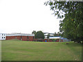
Thurrock & Basildon College
The Basildon campus of this further education college.
Image: © John Winfield
Taken: 23 Sep 2005
0.23 miles
5
Bridleway running north from Dry Street
This is actually mapped as 'The Bridle Way'.
Image: © Robin Webster
Taken: 13 Nov 2010
0.23 miles
6
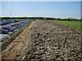
Cars 1 Playing field 0
The result of increased pressure for car parking from the hospital on the left resulted in loss of playing field from Basildon and Thurrock College, which retains only a third of its playing field.
Image: © William Metcalfe
Taken: 19 Apr 2007
0.24 miles