IMAGES TAKEN NEAR TO
Wetherland, BASILDON, SS16 5QN
Introduction
This page details the photographs taken nearby to Wetherland, SS16 5QN by members of the Geograph project.
The Geograph project started in 2005 with the aim of publishing, organising and preserving representative images for every square kilometre of Great Britain, Ireland and the Isle of Man.

There are currently over 7.5m images from over14,400 individuals and you can help contribute to the project by visiting https://www.geograph.org.uk
Image Map (Loading...)


Getting Data...Please wait
Leaflet Map data © OpenStreetMap
Images are licensed for reuse under creativecommons.org/licenses/by-sa/2.0
Notes
- Clicking on the map will re-center to the selected point.
- The higher the marker number, the further away the image location is from the centre of the postcode.
Image Listing (39 Images Found)
Images are licensed for reuse under creativecommons.org/licenses/by-sa/2.0
Image
Details
Distance
1
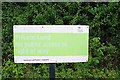
Pointless Sign
It is impossible to read the sign unless you are already trespassing!
see Image
Image: © Glyn Baker
Taken: 15 Jun 2020
0.13 miles
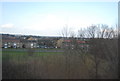
2
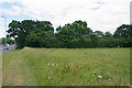
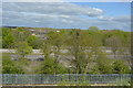
Open Space by B1007 London Link
I had assumed this open space was some kind of nature reserve as there was Image, Image, Image and many other grassland plants as well as reptile census covers. However, in the far distance to the left you can see a Image
Image: © Glyn Baker
Taken: 15 Jun 2020
0.13 miles
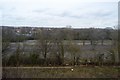
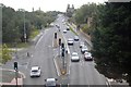
5
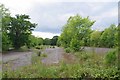
Abandoned Car Park in Lee Chapel North
See what it looked like three years ago at Image
Image: © Glyn Baker
Taken: 15 Jun 2020
0.14 miles