IMAGES TAKEN NEAR TO
Dry Street, BASILDON, SS16 5ND
Introduction
This page details the photographs taken nearby to Dry Street, SS16 5ND by members of the Geograph project.
The Geograph project started in 2005 with the aim of publishing, organising and preserving representative images for every square kilometre of Great Britain, Ireland and the Isle of Man.

There are currently over 7.5m images from over14,400 individuals and you can help contribute to the project by visiting https://www.geograph.org.uk
Image Map
Images are licensed for reuse under creativecommons.org/licenses/by-sa/2.0
Notes
- Clicking on the map will re-center to the selected point.
- The higher the marker number, the further away the image location is from the centre of the postcode.
Image Listing (12 Images Found)
Images are licensed for reuse under creativecommons.org/licenses/by-sa/2.0
Image
Details
Distance
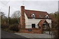
1
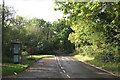
Telephone and Post Boxes
This is a section of Dry Street.
Image: © terry joyce
Taken: 18 Oct 2010
0.04 miles
2
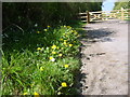
Dandelions
A patch of dandelions brightens up the verge leading to a closed private and gated road off Dry Street.
Image: © William Metcalfe
Taken: 19 Apr 2007
0.04 miles
3
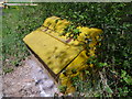
Grit container
This container on Dry Street is overflowing with its rocksalt and grit mixture.
The gradient on this road makes it a difficult route when icy.
Image: © William Metcalfe
Taken: 19 Apr 2007
0.05 miles
4
Newly gated private road
Local residents have closed off the entrance to their private road off Dry Street, claiming unauthorised horse riders have caused it to deteriorate.
Image: © William Metcalfe
Taken: 19 Apr 2007
0.05 miles
5
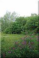
Open land under threat
Looking at this picture it's difficult to imagine that the centre of Basildon New Town is about a mile away. Sadly, though, this area near Dry Site is under threat from developers who plan to put over 1,000 homes on the site. The Council tried to get the area classified as green belt - but failed
Image: © David Williams
Taken: 20 Jul 2006
0.18 miles
6
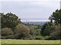
View of the River Thames from Westley Heights Nature Reserve, Langdon Hills
Image: © Derek Voller
Taken: 9 Oct 2013
0.19 miles
7
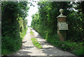
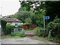
Wootton House Kennels
Entrance to Wootton House Kennels that were once a TB sanatorium,
Image: © Ray Beer
Taken: 15 Jun 2006
0.19 miles
9
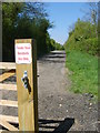
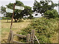
Expanding Footpath #163
This picture shows an encouraging trend; increasing access to the countryside. Not long ago this was only a footpath now it is a bridleway and part of the national cycle network. The blue and white sign is advertising Image Nature Reserve.
Image: © Glyn Baker
Taken: 10 Sep 2005
0.21 miles
10
Pea Patch
Image: © Glyn Baker
Taken: 3 Jul 2009
0.22 miles