IMAGES TAKEN NEAR TO
The Glade, BASILDON, SS16 5JE
Introduction
This page details the photographs taken nearby to The Glade, SS16 5JE by members of the Geograph project.
The Geograph project started in 2005 with the aim of publishing, organising and preserving representative images for every square kilometre of Great Britain, Ireland and the Isle of Man.

There are currently over 7.5m images from over14,400 individuals and you can help contribute to the project by visiting https://www.geograph.org.uk
Image Map
Images are licensed for reuse under creativecommons.org/licenses/by-sa/2.0
Notes
- Clicking on the map will re-center to the selected point.
- The higher the marker number, the further away the image location is from the centre of the postcode.
Image Listing (10 Images Found)
Images are licensed for reuse under creativecommons.org/licenses/by-sa/2.0
Image
Details
Distance
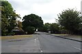
3
Basildon Golf Course
A view south from Clay Hill Road
Image: © John Winfield
Taken: 9 Dec 2005
0.16 miles
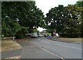
6
The Owl & Pussycat, Basildon
On Clay Hill Road.
See Image] for sign.
Image: © JThomas
Taken: 23 Aug 2022
0.18 miles
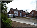
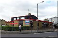
7
The Owl & Pussycat, Basildon
On Clay Hill Road.
See Image] for sign.
Image: © JThomas
Taken: 23 Aug 2022
0.18 miles
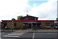
8
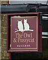
Sign for the Owl & Pussycat, Basildon
Image: © JThomas
Taken: 23 Aug 2022
0.18 miles
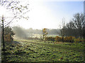
9
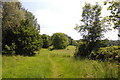
Footpath, Kingswood
Looking south along the footpath just after it has left Clay Hill Road.
Image: © Trevor Harris
Taken: 14 Jun 2010
0.19 miles