IMAGES TAKEN NEAR TO
The Meads, BASILDON, SS16 4TP
Introduction
This page details the photographs taken nearby to The Meads, SS16 4TP by members of the Geograph project.
The Geograph project started in 2005 with the aim of publishing, organising and preserving representative images for every square kilometre of Great Britain, Ireland and the Isle of Man.

There are currently over 7.5m images from over14,400 individuals and you can help contribute to the project by visiting https://www.geograph.org.uk
Image Map
Images are licensed for reuse under creativecommons.org/licenses/by-sa/2.0
Notes
- Clicking on the map will re-center to the selected point.
- The higher the marker number, the further away the image location is from the centre of the postcode.
Image Listing (13 Images Found)
Images are licensed for reuse under creativecommons.org/licenses/by-sa/2.0
Image
Details
Distance
2
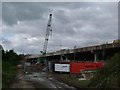
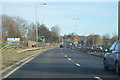
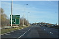
Repairs to the A13
This picture was taken looking west along the footpath that runs parallel with and in-between the A13 and the “Tilbury Loop” of the LT&S railway. Currently the road bridge is being repaired.
Image: © Glyn Baker
Taken: 1 Oct 2005
0.14 miles