IMAGES TAKEN NEAR TO
Vange By-Pass, BASILDON, SS16 4QG
Introduction
This page details the photographs taken nearby to Vange By-Pass, SS16 4QG by members of the Geograph project.
The Geograph project started in 2005 with the aim of publishing, organising and preserving representative images for every square kilometre of Great Britain, Ireland and the Isle of Man.

There are currently over 7.5m images from over14,400 individuals and you can help contribute to the project by visiting https://www.geograph.org.uk
Image Map
Images are licensed for reuse under creativecommons.org/licenses/by-sa/2.0
Notes
- Clicking on the map will re-center to the selected point.
- The higher the marker number, the further away the image location is from the centre of the postcode.
Image Listing (9 Images Found)
Images are licensed for reuse under creativecommons.org/licenses/by-sa/2.0
Image
Details
Distance
3
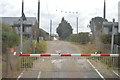
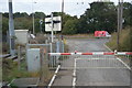
Level Crossing at Marsh Farm, Vange
Just beside the A13, this crossing takes the track to Marsh Farm across the C2C Fenchurch Street to Southend line.
Image: © Trevor Harris
Taken: 2 Dec 2008
0.14 miles
9
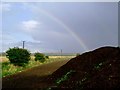
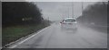
Mixed Metaphors?
There may not be a crock of gold at the end of this rainbow but perhaps where there’s muck there’s brass! Photo taken looking in an easterly direction by a very damp geographer. It does not show well in the photo but there was a distinct second order refraction. For a few minutes there was a full double rainbow, the last vestiges of the spectrum were still visible an hour later. I couldn’t find a category for “Dung Heap” but agricultural activity seemed appropriate given the distinct aroma pervading the area.
Image: © Glyn Baker
Taken: 1 Oct 2005
0.21 miles