IMAGES TAKEN NEAR TO
Mollands, BASILDON, SS16 4LD
Introduction
This page details the photographs taken nearby to Mollands, SS16 4LD by members of the Geograph project.
The Geograph project started in 2005 with the aim of publishing, organising and preserving representative images for every square kilometre of Great Britain, Ireland and the Isle of Man.

There are currently over 7.5m images from over14,400 individuals and you can help contribute to the project by visiting https://www.geograph.org.uk
Image Map
Images are licensed for reuse under creativecommons.org/licenses/by-sa/2.0
Notes
- Clicking on the map will re-center to the selected point.
- The higher the marker number, the further away the image location is from the centre of the postcode.
Image Listing (10 Images Found)
Images are licensed for reuse under creativecommons.org/licenses/by-sa/2.0
Image
Details
Distance
5
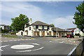
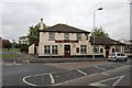
The Barge, Vange (closed)
A sign says a lease is available.
Image: © Robin Webster
Taken: 28 May 2017
0.13 miles
7
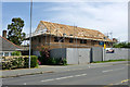
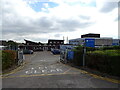
Building site, Clay Hill Road
This is on the site of a quite modern and smart detached bungalow flanked by a double garage, thus having a long frontage attractive for intensive redevelopment.
Image: © Robin Webster
Taken: 28 May 2017
0.17 miles
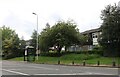
9
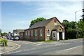
Gordon Mission Hall, Clay Hill Road
Dated 1901, it seems to be more concerned with child care now. The land on which it stands was given on condition it be named after General Gordon (Charles George Gordon, 28/01/1833 - 26/01/1885).
Image: © Robin Webster
Taken: 28 May 2017
0.20 miles
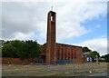
10
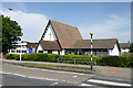
Trinity Methodist Church, Clay Hill Road
Image: © Robin Webster
Taken: 28 May 2017
0.22 miles