IMAGES TAKEN NEAR TO
Great Mistley, BASILDON, SS16 4BE
Introduction
This page details the photographs taken nearby to Great Mistley, SS16 4BE by members of the Geograph project.
The Geograph project started in 2005 with the aim of publishing, organising and preserving representative images for every square kilometre of Great Britain, Ireland and the Isle of Man.

There are currently over 7.5m images from over14,400 individuals and you can help contribute to the project by visiting https://www.geograph.org.uk
Image Map
Images are licensed for reuse under creativecommons.org/licenses/by-sa/2.0
Notes
- Clicking on the map will re-center to the selected point.
- The higher the marker number, the further away the image location is from the centre of the postcode.
Image Listing (9 Images Found)
Images are licensed for reuse under creativecommons.org/licenses/by-sa/2.0
Image
Details
Distance
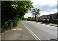
1
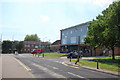
Church Road, Vange
Looking south along Church Road towards its junction with Clay Hill Road.
Image: © Trevor Harris
Taken: 14 Jun 2010
0.06 miles
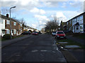
2
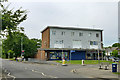
Corner shops with flats, Basildon
On the corner of Clay Hill Road and Church Road.
Image: © Robin Webster
Taken: 28 May 2017
0.06 miles
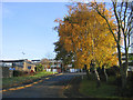
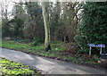
6
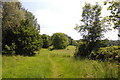
Footpath, Kingswood
Looking south along the footpath just after it has left Clay Hill Road.
Image: © Trevor Harris
Taken: 14 Jun 2010
0.22 miles
7
Osborne Road
This road runs parallel to the railway line. Several paths including Image can be accessed from here.
Image: © terry joyce
Taken: 26 Jan 2012
0.22 miles
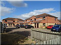
8
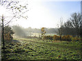
Basildon Golf Course
A view south from Clay Hill Road
Image: © John Winfield
Taken: 9 Dec 2005
0.23 miles
9
Puck Lane
Taken from Osborne Road. Puck Lane is approximately 0.25 mile long. The other end of the path can be accessed from Clay Hill Road.
Image: © terry joyce
Taken: 26 Jan 2012
0.24 miles