IMAGES TAKEN NEAR TO
Tonbridge Drive, BASILDON, SS15 6ND
Introduction
This page details the photographs taken nearby to Tonbridge Drive, SS15 6ND by members of the Geograph project.
The Geograph project started in 2005 with the aim of publishing, organising and preserving representative images for every square kilometre of Great Britain, Ireland and the Isle of Man.

There are currently over 7.5m images from over14,400 individuals and you can help contribute to the project by visiting https://www.geograph.org.uk
Image Map (Loading...)


Getting Data...Please wait
Leaflet Map data © OpenStreetMap
Images are licensed for reuse under creativecommons.org/licenses/by-sa/2.0
Notes
- Clicking on the map will re-center to the selected point.
- The higher the marker number, the further away the image location is from the centre of the postcode.
Image Listing (9 Images Found)
Images are licensed for reuse under creativecommons.org/licenses/by-sa/2.0
Image
Details
Distance
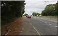
4
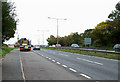
Southend bound
Taken from the layby on the A127 on the Southend on Sea bound carriageway.
Image: © terry joyce
Taken: 29 Oct 2010
0.20 miles
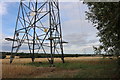
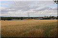
6
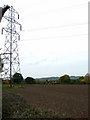
Pylon Power
Taken from near the layby on the A127 looking towards Dunton Wayletts.
Image: © terry joyce
Taken: 29 Oct 2010
0.21 miles
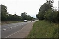
7
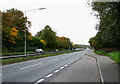
A127 Arterial Road
Taken from the layby looking towards Dunton.
Image: © terry joyce
Taken: 29 Oct 2010
0.21 miles
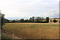
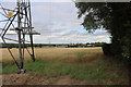
8
Fields around Steeple View Farm, Laindon
Image: © David Howard
Taken: 26 Jul 2020
0.22 miles