IMAGES TAKEN NEAR TO
Compton Walk, BASILDON, SS15 6BL
Introduction
This page details the photographs taken nearby to Compton Walk, SS15 6BL by members of the Geograph project.
The Geograph project started in 2005 with the aim of publishing, organising and preserving representative images for every square kilometre of Great Britain, Ireland and the Isle of Man.

There are currently over 7.5m images from over14,400 individuals and you can help contribute to the project by visiting https://www.geograph.org.uk
Image Map
Images are licensed for reuse under creativecommons.org/licenses/by-sa/2.0
Notes
- Clicking on the map will re-center to the selected point.
- The higher the marker number, the further away the image location is from the centre of the postcode.
Image Listing (8 Images Found)
Images are licensed for reuse under creativecommons.org/licenses/by-sa/2.0
Image
Details
Distance

2
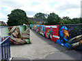
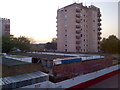
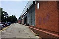
Footbridge, Laindon
One of the less successful neighbourhood retail areas of Basildon New Town (judging by appearances) is connected to a residential area by this concrete footbridge over a service road. The original drab appearance has been livened up.
Image: © Robin Webster
Taken: 9 Jul 2015
0.20 miles
3
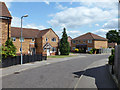
Houses on Chancel Close, Laindon
Laindon has been converted into a suburb of Basildon.
Image: © Robin Webster
Taken: 9 Jul 2015
0.22 miles
6
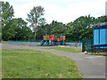
Play area, Laindon
In a small recreation ground between Worthing Way and West Mayne.
Image: © Robin Webster
Taken: 9 Jul 2015
0.24 miles
7
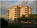
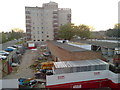
Royal Court on Brookmeade; Laindon
“High Rise” accommodation is not a common feature of Laindon but the 1960’s high density living planners still managed to throw up a couple of blocks here.
Image: © Glyn Baker
Taken: 27 Sep 2005
0.25 miles