IMAGES TAKEN NEAR TO
Princes Close, BASILDON, SS15 5YH
Introduction
This page details the photographs taken nearby to Princes Close, SS15 5YH by members of the Geograph project.
The Geograph project started in 2005 with the aim of publishing, organising and preserving representative images for every square kilometre of Great Britain, Ireland and the Isle of Man.

There are currently over 7.5m images from over14,400 individuals and you can help contribute to the project by visiting https://www.geograph.org.uk
Image Map (Loading...)


Getting Data...Please wait
Leaflet Map data © OpenStreetMap
Images are licensed for reuse under creativecommons.org/licenses/by-sa/2.0
Notes
- Clicking on the map will re-center to the selected point.
- The higher the marker number, the further away the image location is from the centre of the postcode.
Image Listing (10 Images Found)
Images are licensed for reuse under creativecommons.org/licenses/by-sa/2.0
Image
Details
Distance
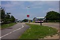
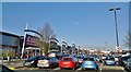
1
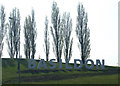
Basildon Sign
The sign is near to the exit from the A127 onto the A176.
Image: © terry joyce
Taken: 27 Apr 2010
0.08 miles
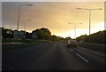
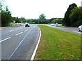
4
Southend Arterial Road, Noak Bridge
I don't remember seeing such a bright sunbeam before. They normally poke out through rain clouds.
Image: © David Howard
Taken: 8 Apr 2019
0.15 miles
6
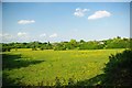
Basildon!
This meadow is only a few minutes walk from the heart of Basildon, there are numerous signs declaring it as private property
Image: © Glyn Baker
Taken: 19 May 2011
0.21 miles