IMAGES TAKEN NEAR TO
Laindon Link, BASILDON, SS15 5UN
Introduction
This page details the photographs taken nearby to Laindon Link, SS15 5UN by members of the Geograph project.
The Geograph project started in 2005 with the aim of publishing, organising and preserving representative images for every square kilometre of Great Britain, Ireland and the Isle of Man.

There are currently over 7.5m images from over14,400 individuals and you can help contribute to the project by visiting https://www.geograph.org.uk
Image Map
Images are licensed for reuse under creativecommons.org/licenses/by-sa/2.0
Notes
- Clicking on the map will re-center to the selected point.
- The higher the marker number, the further away the image location is from the centre of the postcode.
Image Listing (5 Images Found)
Images are licensed for reuse under creativecommons.org/licenses/by-sa/2.0
Image
Details
Distance
3
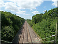
Railway between Basildon and Laindon
The LTSR cut-off line from Barking to Pitsea. Here it is climbing to the summit of the line at Laindon in surmounting Langdon Hills.
Image: © Robin Webster
Taken: 9 Jul 2015
0.19 miles
4
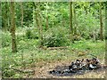
Brambles Bush & Burned out Bike
Image is managed by the Essex Wildlife Trust http://www.essexwt.org.uk/visitor_centres__nature_reserves/langdon/
The reserve is a sliver of woodland between the B1036 and the railway between Laindon and Basildon. The burned out bike reminding us we are on the outskirts of an urban area. The undergrowth has been cleared in this area to help diversify the habitat.
Image: © Glyn Baker
Taken: 10 Sep 2005
0.22 miles
5
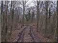
Track into Hoppit Shaw, Langdon Nature Reserve
Track into the wooded section of Hoppit Shaw, part of the Essex Wildlife Trust's Langdon Nature Reserve.
Image: © Roger Jones
Taken: 24 Feb 2013
0.24 miles