IMAGES TAKEN NEAR TO
Basildon Road, BASILDON, SS15 5SF
Introduction
This page details the photographs taken nearby to Basildon Road, SS15 5SF by members of the Geograph project.
The Geograph project started in 2005 with the aim of publishing, organising and preserving representative images for every square kilometre of Great Britain, Ireland and the Isle of Man.

There are currently over 7.5m images from over14,400 individuals and you can help contribute to the project by visiting https://www.geograph.org.uk
Image Map
Images are licensed for reuse under creativecommons.org/licenses/by-sa/2.0
Notes
- Clicking on the map will re-center to the selected point.
- The higher the marker number, the further away the image location is from the centre of the postcode.
Image Listing (12 Images Found)
Images are licensed for reuse under creativecommons.org/licenses/by-sa/2.0
Image
Details
Distance
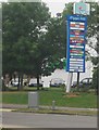
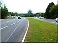
2

Basildon Sign
The sign is near to the exit from the A127 onto the A176.
Image: © terry joyce
Taken: 27 Apr 2010
0.17 miles
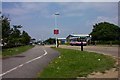
5
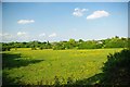
Basildon!
This meadow is only a few minutes walk from the heart of Basildon, there are numerous signs declaring it as private property
Image: © Glyn Baker
Taken: 19 May 2011
0.19 miles
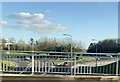
7
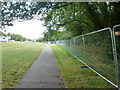
Path by St. Nicholas Lane
The park on the right is totally cordoned off - is it to be a park no longer?
Image: © Robin Webster
Taken: 9 Jul 2015
0.21 miles