IMAGES TAKEN NEAR TO
Gladwyns, BASILDON, SS15 5JA
Introduction
This page details the photographs taken nearby to Gladwyns, SS15 5JA by members of the Geograph project.
The Geograph project started in 2005 with the aim of publishing, organising and preserving representative images for every square kilometre of Great Britain, Ireland and the Isle of Man.

There are currently over 7.5m images from over14,400 individuals and you can help contribute to the project by visiting https://www.geograph.org.uk
Image Map
Images are licensed for reuse under creativecommons.org/licenses/by-sa/2.0
Notes
- Clicking on the map will re-center to the selected point.
- The higher the marker number, the further away the image location is from the centre of the postcode.
Image Listing (4 Images Found)
Images are licensed for reuse under creativecommons.org/licenses/by-sa/2.0
Image
Details
Distance
1
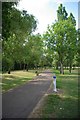
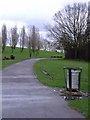
Cycleway 13 Through Gloucester Park
Cycleway 13 runs parallel with Upper Mane at this point
Image: © Glyn Baker
Taken: 19 May 2011
0.18 miles
2
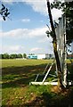
Gloucester Park (Basildon) Cricket ground
There is another Gloucester Park Cricket Ground that is somewhat more famous!
Image: © Glyn Baker
Taken: 19 May 2011
0.20 miles
3
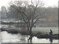
It's never too cold to fish
The lake had frozen over so the angler had broken enough ice to fish through
Image: © Paul Dodd
Taken: 30 Dec 2008
0.20 miles