IMAGES TAKEN NEAR TO
Great Knightleys, BASILDON, SS15 5AL
Introduction
This page details the photographs taken nearby to Great Knightleys, SS15 5AL by members of the Geograph project.
The Geograph project started in 2005 with the aim of publishing, organising and preserving representative images for every square kilometre of Great Britain, Ireland and the Isle of Man.

There are currently over 7.5m images from over14,400 individuals and you can help contribute to the project by visiting https://www.geograph.org.uk
Image Map
Images are licensed for reuse under creativecommons.org/licenses/by-sa/2.0
Notes
- Clicking on the map will re-center to the selected point.
- The higher the marker number, the further away the image location is from the centre of the postcode.
Image Listing (25 Images Found)
Images are licensed for reuse under creativecommons.org/licenses/by-sa/2.0
Image
Details
Distance
4
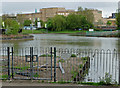
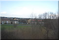
Gloucester Park Lakes
A haven of tranquil beauty in the southwest corner of Basildon's Gloucester Park. It is a pity that swimming and paddling are not allowed.
Image: © John Allan
Taken: 13 May 2013
0.16 miles
5
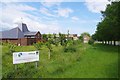
Our Lady & All Saints Community Orchard
Apple & Pear trees read the sign at Image
Image: © Glyn Baker
Taken: 15 Jun 2020
0.17 miles
8
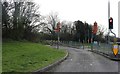
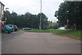
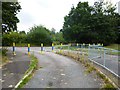
The road to nowhere, Basildon
This was a car park entrance but it has been blocked.
Image: © David Howard
Taken: 9 Mar 2019
0.17 miles
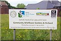
10
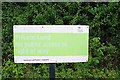
Pointless Sign
It is impossible to read the sign unless you are already trespassing!
see Image
Image: © Glyn Baker
Taken: 15 Jun 2020
0.18 miles