IMAGES TAKEN NEAR TO
Dunton Road, BASILDON, SS15 4BU
Introduction
This page details the photographs taken nearby to Dunton Road, SS15 4BU by members of the Geograph project.
The Geograph project started in 2005 with the aim of publishing, organising and preserving representative images for every square kilometre of Great Britain, Ireland and the Isle of Man.

There are currently over 7.5m images from over14,400 individuals and you can help contribute to the project by visiting https://www.geograph.org.uk
Image Map
Images are licensed for reuse under creativecommons.org/licenses/by-sa/2.0
Notes
- Clicking on the map will re-center to the selected point.
- The higher the marker number, the further away the image location is from the centre of the postcode.
Image Listing (17 Images Found)
Images are licensed for reuse under creativecommons.org/licenses/by-sa/2.0
Image
Details
Distance
1
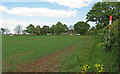
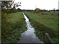
Tributary, River Crouch
This drain/stream appears behind houses in High Road North, Laindon. It flows north and joins the River Crouch near the bottom of Noak Hill Road.
Image: © terry joyce
Taken: 4 Nov 2011
0.03 miles
2
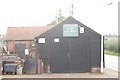
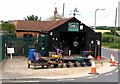
The Forge, Noak Bridge
The forge is that of V and J Quelch and Son, a working blacksmith's.
Image: © Trevor Harris
Taken: 1 Sep 2008
0.08 miles
3
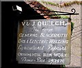
V and J Quelch and Son General Blacksmith sign
Image: © Andrew Tatlow
Taken: 26 Jul 2013
0.09 miles
4

V and J Quelch and Son General Blacksmith sign
Image: © Andrew Tatlow
Taken: 26 Jul 2013
0.10 miles
5
V and J Quelch and Son General Blacksmith
Image: © Andrew Tatlow
Taken: 26 Jul 2013
0.10 miles
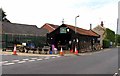
6
V and J Quelch and Son General Blacksmith
Image: © Andrew Tatlow
Taken: 26 Jul 2013
0.10 miles
7
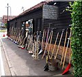
V and J Quelch and Son General Blacksmith
Image: © Andrew Tatlow
Taken: 26 Jul 2013
0.10 miles
8

Old Milestone by Laindon High Road, Laindon parish
Carved stone post by the UC road, in parish of Laindon (BASILDON District), Laindon High Road (North). 30m South of Dunton Road junction, by the road, on East side of road. Erected by the Thundersley to Horndon turnpike trust in the 19th century.
Inscription not recorded.
Essex HER.
SMR Number: 15177 https://www.heritagegateway.org.uk/Gateway/Results_Single.aspx?uid=MEX1034904&resourceID=1001
Milestone Society National ID: EX_BITF01
Image: © JV Nicholls
Taken: 26 Feb 2011
0.10 miles
9
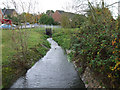
Tributary, River Crouch
This drain/stream has just passed under Dunton Road and joins the River Crouch near the bottom of Noak Hill.
Image: © terry joyce
Taken: 4 Nov 2011
0.11 miles