IMAGES TAKEN NEAR TO
Rochester Way, BASILDON, SS14 3QL
Introduction
This page details the photographs taken nearby to Rochester Way, SS14 3QL by members of the Geograph project.
The Geograph project started in 2005 with the aim of publishing, organising and preserving representative images for every square kilometre of Great Britain, Ireland and the Isle of Man.

There are currently over 7.5m images from over14,400 individuals and you can help contribute to the project by visiting https://www.geograph.org.uk
Image Map (Loading...)


Getting Data...Please wait
Leaflet Map data © OpenStreetMap
Images are licensed for reuse under creativecommons.org/licenses/by-sa/2.0
Notes
- Clicking on the map will re-center to the selected point.
- The higher the marker number, the further away the image location is from the centre of the postcode.
Image Listing (5 Images Found)
Images are licensed for reuse under creativecommons.org/licenses/by-sa/2.0
Image
Details
Distance
1
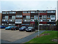
Maisonettes in Fryerns
Basildon's impersonation of 1970s East Germany. The area is scheduled for redevelopment.
Image: © John Allan
Taken: 19 Sep 2011
0.10 miles
2
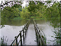
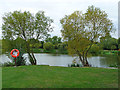
The Bridge
The nearby stream overflowed into the lake after Heavy rain
Image: © Paul Dodd
Taken: 20 Oct 2008
0.21 miles