IMAGES TAKEN NEAR TO
Quatro Business Park, Paycocke Road, BASILDON, SS14 3GH
Introduction
This page details the photographs taken nearby to Quatro Business Park, Paycocke Road, SS14 3GH by members of the Geograph project.
The Geograph project started in 2005 with the aim of publishing, organising and preserving representative images for every square kilometre of Great Britain, Ireland and the Isle of Man.

There are currently over 7.5m images from over14,400 individuals and you can help contribute to the project by visiting https://www.geograph.org.uk
Image Map
Images are licensed for reuse under creativecommons.org/licenses/by-sa/2.0
Notes
- Clicking on the map will re-center to the selected point.
- The higher the marker number, the further away the image location is from the centre of the postcode.
Image Listing (13 Images Found)
Images are licensed for reuse under creativecommons.org/licenses/by-sa/2.0
Image
Details
Distance

2

Remnants of a Moat
This picture shows part of the remains of the moat that once surrounded Cranes Farm in Basildon. The road in the background is the A1235 Cranes Farm Rd.
Image: © Glyn Baker
Taken: 9 Jan 2010
0.14 miles
4

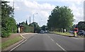
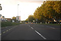
Paycocke Road, Cranes, Basildon
Cranes is an area of light industrial units, offices and outlets on the eastern side of Basildon.
Image: © Trevor Harris
Taken: 13 Sep 2022
0.15 miles
5

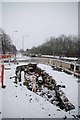
New Pipes
New gas pipes waiting for installation under the A1235 Cranes Farm Road Basildon
Image: © Glyn Baker
Taken: 9 Jan 2010
0.15 miles
7
Gas Works?
This hole in the ground is waiting for Image
Image: © Glyn Baker
Taken: 9 Jan 2010
0.15 miles