IMAGES TAKEN NEAR TO
Christopher Martin Road, BASILDON, SS14 3FU
Introduction
This page details the photographs taken nearby to Christopher Martin Road, SS14 3FU by members of the Geograph project.
The Geograph project started in 2005 with the aim of publishing, organising and preserving representative images for every square kilometre of Great Britain, Ireland and the Isle of Man.

There are currently over 7.5m images from over14,400 individuals and you can help contribute to the project by visiting https://www.geograph.org.uk
Image Map
Images are licensed for reuse under creativecommons.org/licenses/by-sa/2.0
Notes
- Clicking on the map will re-center to the selected point.
- The higher the marker number, the further away the image location is from the centre of the postcode.
Image Listing (7 Images Found)
Images are licensed for reuse under creativecommons.org/licenses/by-sa/2.0
Image
Details
Distance
1
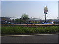
Shopping complex on Christopher Martin Road from the A127
Image: © David Howard
Taken: 24 May 2012
0.09 miles
2

DSA Multi Purpose Test Centre
This is the Basildon MPTC for Cars and Motorbikes.
Image: © terry joyce
Taken: 16 Jun 2010
0.09 miles
3
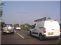
Holdup on the A127, Basildon
It was like this for a few miles but progress was steady.
Image: © David Howard
Taken: 24 May 2012
0.10 miles
4
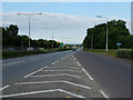
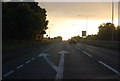
The A127 at Gardiners Lane
Looking in the direction of Southend from the junction that serves the Mayflower Retail Park, Basildon.
Image: © John Allan
Taken: 10 Jun 2013
0.13 miles
5

Demolition in progress
The building that was here was owned by a company called Visteon.
Image: © terry joyce
Taken: 16 Jun 2010
0.13 miles