IMAGES TAKEN NEAR TO
The Fremnells, BASILDON, SS14 2QZ
Introduction
This page details the photographs taken nearby to The Fremnells, SS14 2QZ by members of the Geograph project.
The Geograph project started in 2005 with the aim of publishing, organising and preserving representative images for every square kilometre of Great Britain, Ireland and the Isle of Man.

There are currently over 7.5m images from over14,400 individuals and you can help contribute to the project by visiting https://www.geograph.org.uk
Image Map (Loading...)


Getting Data...Please wait
Leaflet Map data © OpenStreetMap
Images are licensed for reuse under creativecommons.org/licenses/by-sa/2.0
Notes
- Clicking on the map will re-center to the selected point.
- The higher the marker number, the further away the image location is from the centre of the postcode.
Image Listing (10 Images Found)
Images are licensed for reuse under creativecommons.org/licenses/by-sa/2.0
Image
Details
Distance
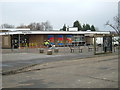
5
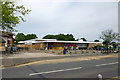
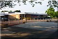
Fryerns Library and Community Centre, Basildon
On Whitmore Way.
Image: © Robin Webster
Taken: 28 May 2017
0.17 miles

10
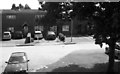
Fryerns Library, Basildon
Behind the Library is a community centre and to the left a parade of shops. The photo was taken looking north across Whitmore Way
Image: © Glyn Baker
Taken: 16 Jan 2006
0.24 miles