IMAGES TAKEN NEAR TO
Redshank Close, BASILDON, SS14 2GF
Introduction
This page details the photographs taken nearby to Redshank Close, SS14 2GF by members of the Geograph project.
The Geograph project started in 2005 with the aim of publishing, organising and preserving representative images for every square kilometre of Great Britain, Ireland and the Isle of Man.

There are currently over 7.5m images from over14,400 individuals and you can help contribute to the project by visiting https://www.geograph.org.uk
Image Map
Images are licensed for reuse under creativecommons.org/licenses/by-sa/2.0
Notes
- Clicking on the map will re-center to the selected point.
- The higher the marker number, the further away the image location is from the centre of the postcode.
Image Listing (23 Images Found)
Images are licensed for reuse under creativecommons.org/licenses/by-sa/2.0
Image
Details
Distance
5
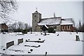
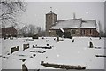
Winter at Holy Cross
Image: © Glyn Baker
Taken: 9 Jan 2010
0.11 miles
6
Snittering Around The Holy Cross
This is Image you can see the scene about an hour earlier than the photo above at Image Learn more about the church at http://www.essexchurches.info/church.asp?p=Basildon&ty=e
(N.B snitter is the verb to snow check it out in the OED!)
Image: © Glyn Baker
Taken: 9 Jan 2010
0.11 miles
7
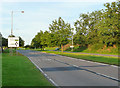
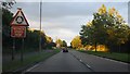
Cranes Farm Road
The eastbound A1235 approaching the New Holland Tractor Plant.
Image
Image: © John Allan
Taken: 14 Aug 2012
0.12 miles