IMAGES TAKEN NEAR TO
Timberlog Lane, BASILDON, SS14 1PG
Introduction
This page details the photographs taken nearby to Timberlog Lane, SS14 1PG by members of the Geograph project.
The Geograph project started in 2005 with the aim of publishing, organising and preserving representative images for every square kilometre of Great Britain, Ireland and the Isle of Man.

There are currently over 7.5m images from over14,400 individuals and you can help contribute to the project by visiting https://www.geograph.org.uk
Image Map
Images are licensed for reuse under creativecommons.org/licenses/by-sa/2.0
Notes
- Clicking on the map will re-center to the selected point.
- The higher the marker number, the further away the image location is from the centre of the postcode.
Image Listing (9 Images Found)
Images are licensed for reuse under creativecommons.org/licenses/by-sa/2.0
Image
Details
Distance
1
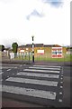
Timberlog Youth Centre
The youth centre in Barstable
Image: © Glyn Baker
Taken: 27 Apr 2016
0.02 miles
2
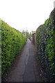
Ivy Path
Where I come from this sort of urban footpath is known as a Folley.
Image: © Glyn Baker
Taken: 27 Apr 2016
0.03 miles
3

Small Goal & Telecoms Tower
A play area in Barstable.
Image: © Glyn Baker
Taken: 27 Apr 2016
0.11 miles
4

Maisonetes in Long Riding
Looking towards Timberlog Lane
Image: © Glyn Baker
Taken: 27 Apr 2016
0.13 miles
5
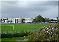
Barstable School
Originally Barstable Grammar School, now the Basildon Lower Academy.
Image: © terry joyce
Taken: 16 Oct 2010
0.19 miles
7
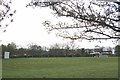
Basildon & Pitsea Cricket Club
This is the home ground for the Basildon & Pitsea Cricket Club http://basildoncricket.hitscricket.com/default.aspx
Image: © Glyn Baker
Taken: 27 Apr 2016
0.22 miles
8
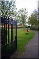
Gate to Mopsies Park
A recreation ground in Barstable.
Image: © Glyn Baker
Taken: 27 Apr 2016
0.24 miles
9
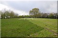
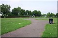
Mopsies Park
A very strange mowing pattern especially for a footie pitch.
Image: © Glyn Baker
Taken: 27 Apr 2016
0.24 miles