IMAGES TAKEN NEAR TO
Thurlow Drive, SOUTHEND-ON-SEA, SS1 3DD
Introduction
This page details the photographs taken nearby to Thurlow Drive, SS1 3DD by members of the Geograph project.
The Geograph project started in 2005 with the aim of publishing, organising and preserving representative images for every square kilometre of Great Britain, Ireland and the Isle of Man.

There are currently over 7.5m images from over14,400 individuals and you can help contribute to the project by visiting https://www.geograph.org.uk
Image Map
Images are licensed for reuse under creativecommons.org/licenses/by-sa/2.0
Notes
- Clicking on the map will re-center to the selected point.
- The higher the marker number, the further away the image location is from the centre of the postcode.
Image Listing (8 Images Found)
Images are licensed for reuse under creativecommons.org/licenses/by-sa/2.0
Image
Details
Distance
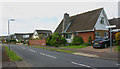
2
Wyatts Drive, Southend
The house whose side elevation can be seen on the right is in Woodgrange Drive.
Image: © David Kemp
Taken: 30 Apr 2020
0.05 miles
4
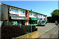
Shopping parade, Woodgrange Drive, Southend
This is the shopping parade opposite Chelsworth Crescent.
Image: © David Kemp
Taken: 22 Apr 2020
0.10 miles
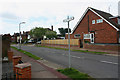
6
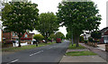
East end of Woodgrange Drive, Southend
Taken from the corner of Wyatts Drive.
Image: © David Kemp
Taken: 30 Apr 2020
0.13 miles
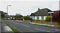
7
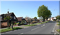
Woodgrange Drive, Southend
Taken from near the corner of Chelsworth Crescent.
Image: © David Kemp
Taken: 22 Apr 2020
0.17 miles
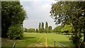
8
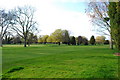
Thorpe Hall golf course
Taken from the public footpath through the course
Image: © william
Taken: 22 Mar 2009
0.23 miles