IMAGES TAKEN NEAR TO
Carlisle Way, BASILDON, SS13 3RF
Introduction
This page details the photographs taken nearby to Carlisle Way, SS13 3RF by members of the Geograph project.
The Geograph project started in 2005 with the aim of publishing, organising and preserving representative images for every square kilometre of Great Britain, Ireland and the Isle of Man.

There are currently over 7.5m images from over14,400 individuals and you can help contribute to the project by visiting https://www.geograph.org.uk
Image Map
Images are licensed for reuse under creativecommons.org/licenses/by-sa/2.0
Notes
- Clicking on the map will re-center to the selected point.
- The higher the marker number, the further away the image location is from the centre of the postcode.
Image Listing (4 Images Found)
Images are licensed for reuse under creativecommons.org/licenses/by-sa/2.0
Image
Details
Distance
1
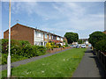
Somerset Gardens
Pedestrian only over this section.
Image: © Robin Webster
Taken: 28 May 2017
0.15 miles
2
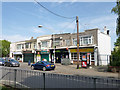
Shops, Rectory Road, Pitsea
Costcutter is also a post office.
Image: © Robin Webster
Taken: 28 May 2017
0.20 miles
3
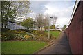
Path to Wickford Ave Underpass
The building to the left is Basildon Upper Academy.
Image: © Glyn Baker
Taken: 27 Apr 2016
0.21 miles
4
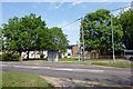
Kenneth Road bus stop on Rectory Road
The southbound stop.
Image: © Robin Webster
Taken: 28 May 2017
0.24 miles