IMAGES TAKEN NEAR TO
Moretons Mews, BASILDON, SS13 3NB
Introduction
This page details the photographs taken nearby to Moretons Mews, SS13 3NB by members of the Geograph project.
The Geograph project started in 2005 with the aim of publishing, organising and preserving representative images for every square kilometre of Great Britain, Ireland and the Isle of Man.

There are currently over 7.5m images from over14,400 individuals and you can help contribute to the project by visiting https://www.geograph.org.uk
Image Map
Images are licensed for reuse under creativecommons.org/licenses/by-sa/2.0
Notes
- Clicking on the map will re-center to the selected point.
- The higher the marker number, the further away the image location is from the centre of the postcode.
Image Listing (3 Images Found)
Images are licensed for reuse under creativecommons.org/licenses/by-sa/2.0
Image
Details
Distance
2
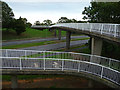
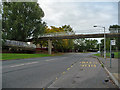
Footbridge over the A132
The bridge connects Barstable, on this side, with Chalvedon on the far side.
Image: © John Allan
Taken: 19 Sep 2011
0.10 miles
3
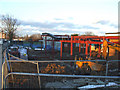
St Teresa's Catholic Primary School
This is an extension that is being built on the front of the school.
Image: © terry joyce
Taken: 8 Jan 2011
0.16 miles